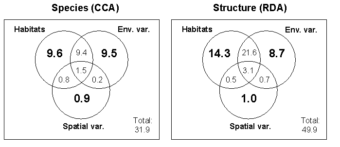
Fig. 3. Venn diagrams representing variance partitioning among the three groups of explanatory variables, namely habitat classes, environmental measures, and spatial variables, using ordination methods. Canonical correspondence analysis (CCA) and redundancy analysis (RDA) were used to model the relationships between species composition (93 species) or vegetation structure (18 strata/groupings) and explanatory variables, respectively. Habitat classes are defined in Table 1. The 15 environmental variables (Env. var.) considered included the depth of the water table; shade cover on ground layer by herbs, sedges, shrubs, and trees; the height of the four tallest trees around each 0.65-m2 plot; the pH of the surface water; the water chemistry of the surface water; and the concentrations of K+, Na+, Ca++, Mg++, Fe++, Al+, P, NO3-, NH4+, and SO4-. The first three variables were originally measured in each of the three 0.65-m2 plots contained in the 20 x 20 m pixel quadrat for the species composition ordination, and then averaged on a pixel quadrat basis (n = 252 quadrats) for the vegetation structure ordination. Water samples were kept frozen at -4ºC until pH and chemical component concentrations were measured in the laboratory. Chemical conductivity was measured in the field and corrected for H+ activity according to Sjørs (1952). Water samples were filtered before testing for chemical elements and isotopes. Concentrations of K+, Na+, Ca++, Mg++, Fe++, Al+, and P were measured by atomic emission using a model P40 Perkin-Elmer inductively coupled plasma mass spectometer. Concentrations of NO3-, NH4+, and SO4- were measured using the flow injection analysis method with a Lachat Quickchem4000. The spatial variables (Spatial var.) were Universal Transverse Mercator coordinates. Their weak explanatory power indicates that there was no geographic bias in the vegetation sampling effort.