|
|
|
Copyright © 2003 by the author(s). Published here under license by The Resilience Alliance.
Go to the pdf version of this article.
The following is the established format for referencing this article:
Toupal, R. S. 2003. Cultural landscapes as a methodology for understanding natural resource management impacts in the western United States. Conservation Ecology 7(1): 12. [online] URL: http://www.consecol.org/vol7/iss1/art12/
A version of this article in which text, figures, tables, and appendices are separate files may be found by following this link.
Report Cultural Landscapes as a Methodology for Understanding Natural Resource Management Impacts in the Western United States Rebecca S. Toupal
University of Arizona
- Abstract
- Introduction
- Methods
- Results
- Discussion
- Responses to this Article
- Acknowledgments
- Literature Cited
Multicultural demands on public lands in the United States continue to challenge federal land managers to address social and cultural concerns in their planning efforts. Specifically, they lack adequate knowledge of cultural concerns, as well as a consistent strategy for acquiring that knowledge for use in decision-making. Current federal approaches to understanding such issues as access, use, and control of resources include public participation, conservation partnerships, government-to-government consultations with American Indian tribes, cultural resource inventories, and landscape analysis. Given that cultural knowledge arises from human–nature relationships and shared perceptions of natural environments, and that landscapes are the ultimate expression of such knowledge, an exploratory methodology was developed to provide a different approach to understanding cultural concerns through landscape perceptions. Using cultural landscape theories and applications from the natural and social sciences, this study examines the landscape perceptions of four groups concerned with management planning of the Baboquivari Wilderness Area in southern Arizona: the Bureau of Land Management, the landowners of the Altar Valley, recreationists, and members of the Tohono O’odham Nation. The methodology is based on a human–nature relationship rather than cultural aspects or features. It takes a holistic approach that differs from other perception studies in that it includes: emic aspects of data collection and analysis; a spatial component (triangulation of data collection through narrative and graphic descriptions); ethnographic, on-site interviews; and cultural consensus analysis and small-sample theory. The results include: verification of four cultural groups; two levels of consensus (in the population of concern, and in each group) that overlap in some aspects of landscape perception; descriptions of four cultural landscapes that illustrate similarities and differences among the groups, and include patterns and representations of spatial relationships; and an effective methodology for revealing cultural concerns that are not identified through public forums, and which has potential for application by agencies at the field-office level.
KEY WORDS: American Indians, cultural landscapes, ethnographic data, landscape perceptions, natural resource management, public participation.
Published: June 3, 2003
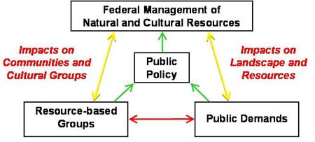
The western United States presents a mosaic of public, private, and tribal land ownership fraught with many cultural perspectives to which federal land managers must respond. Legislation and policies, which result from these perspectives as groups pursue particular agendas, may be incompatible with local cultural systems, giving rise to a self-perpetuating cycle of public input and legislative output (Fig. 1).
|
Fig. 1. Political dynamics of natural and cultural resource management.
|
The federal manager’s challenge to address diverse cultural concerns effectively is compounded by the traditional dichotomous approach to management and policies, which considers natural and cultural resources independent of each other. Methods of public participation, partnerships, and government-to-government consultations with American Indian tribes are the traditional federal responses to cultural concerns. Each approach has specific weaknesses, however, that limit identification of cultural issues and often result in 1) hegemonious decisions that favor more powerful interests over others, 2) public dissatisfaction with government dominance over local communities, and 3) lawsuits.
Public participation meetings tend to become exercises in one-way communication, and the partnership strategy tends to be homogeneous, predominantly involving Euro-American groups and individuals. Frequently missing from both are the American Indian tribes who occupy approximately 53.5 million acres of land (about 7%) in the western states. Decades of failed relations, concerns about protecting sensitive cultural information, and cultural-based norms of decision-making commonly impede participation by American Indian tribes, who have legal standing as dependent sovereign nations. Federal agencies, consequently, must consult with them on a government-to-government basis that excludes public interaction (Appendix 1).
Technical approaches to identification of cultural issues include the Cultural Landscape Inventory (CLI) (Page 1998) and the Ethnographic Resource Inventory (ERI) (Roberts and Evans 2001) developed by the National Park Service (NPS), and Landscape Analysis and Design (LAD) developed by the Forest Service (USFS) (Diaz and Apostol 1993). The CLI is an in-house tool that focuses on material culture and provides a basis for selecting one of potentially many cultures for management and interpretation of resources. The ERI, another in-house tool, relies on historic and contemporary ethnographic data about landscapes, natural resources, objects, and places. The LAD provides the greatest opportunity to identify cultural concerns in that local citizens can participate throughout the inventory, planning, and decision-making processes. However, in addition to having cultural limitations similar to those of partnerships, this approach remains confined to a few USFS planning activities.
Through discussions with the Bureau of Land Management (BLM) and NPS, I identified two specific needs: the need for more cultural knowledge and the need for a consistent strategy to obtain such knowledge for decision-making (Juen personal communication, Walker personal communication). These needs arise in part from a lack of understanding of human–nature relationships and a segregated approach to interacting with the public and managing the landscape.
Inadequate cultural knowledge stems from the current approaches, the formats of which do not bring out deeper understanding of other cultural groups’ relationships with the land. In a public forum, for example, an Indian person might state that the mountain is sacred, which non-Indian people hear as religion. Although religion is part of what is meant by sacred, it is not the entire or even dominant meaning. The lack of understanding results from using one culture’s term for another culture’s concept, and from the reluctance to express intimate feelings or share sensitive knowledge in a public forum (Appendix 2).
The lack of a consistent strategy to obtain cultural knowledge stems from the traditional management approach that relies on biophysical sciences to understand natural resources, and on social sciences, such as history, archaeology, and sociology, to understand cultural resources. Each science may provide an understanding of a resource, but those understandings often are not contextualized or are restricted to material or man-made cultural items.
Seeking alternatives to these problems, I examined landscape and perception theories and applications from natural and social science disciplines, with an emphasis on human–nature relationships, cognitive maps, and cultural constructs of nature. I merged research techniques from these subjects to develop an exploratory methodology with which to describe landscape perceptions held by different cultural groups of a given area. Although the term culture has many definitions, for the purposes of this research, I chose the definition of shared beliefs, values, and norms about a particular knowledge domain, in this case the landscape. I adopted Kempton et al.’s (1997) description of cultural perceptions: that when the mental models of individuals are widely shared, they become cultural models. Through shared experiences, groups of individuals develop, transmit, and, consequently, share beliefs, norms, and knowledge about a specific realm, forming a “consensus” that is interpreted as “cultural” (Holland and Quinn 1987).
By revealing how and to what degree landscapes are important to and valued by different cultural groups, I hoped to provide a deeper understanding of cultural concerns that would allow integration of cultural issues with natural resource management. I intended the methodology to be operable at the field-office level, given some practical training.
The concept of cultural landscapes, which has its roots in cultural geography (Sauer 1931, 1963), provides an organizing construct within which cultural perceptions of and relationships with a natural environment may be characterized by components, uses, and meanings. To make the concept operational, I drew from landscape architecture and cultural anthropology for theories and applications capable of considering multiple temporal scales (Stoffle et al. 1997), intangible processes and phenomena (Zube et al. 1975, 1982, Saarinen 1976, Zube 1980, Kaplan and Kaplan 1982, Austin 1994, Greider and Garkovich 1994, Romney 1994), material culture and the built environment (Page 1998), and qualitative and quantitative methods (Reichardt and Cook 1979, Bernard 1995). I applied this mixed methods approach to sampling, data collection, and statistical analysis.
As the federal land manager is more concerned with multiple interests on a project-by-project basis than with comparing the cultural interests of two or more projects, I chose a single case study to test my methodology. I began with three criteria: (1) a contested management unit with (2) federal jurisdiction that had (3) at least three identifiable cultural groups, including an American Indian tribe. I decided that similarities and differences between groups could be better understood by including the managing agency as a fourth group, given that personal cultural filters hinder an understanding of other cultural groups.
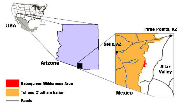
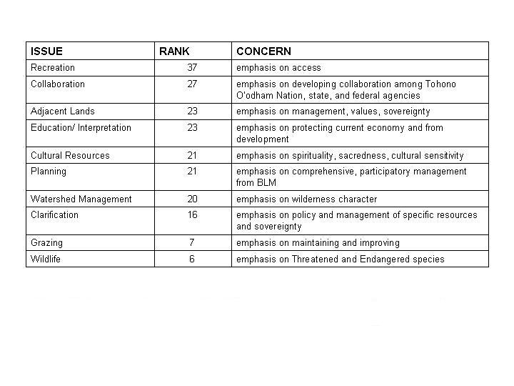
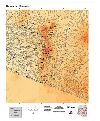
A timely planning mandate for the Baboquivari Wilderness Area in southern Arizona provided an ideal case (Fig. 2). Baboquivari Peak, the most prominent feature of the wilderness area, is highly contested. The BLM has management responsibility for the area, and local landowners, recreationists, and the Tohono O’odham Nation (Papago) are the predominant interest groups. I developed my study design during the course of three public meetings, which confirmed the interest groups as those most affected by the BLM’s decision-making and provided access to individuals and organizations representing those interests. These meetings also produced a ranking of issues and concerns voiced by the participants (Fig. 3).
|
Fig. 2. Baboquivari Wilderness Area location map.
|
|
Fig. 3. Issues and concerns identified by recreationists, landowners, and member of the Tohono O’odham Nation at public meetings held on January 22 and February 12, 2000.
|
Sampling
I examined previous landscape, perception, and cognition studies (McHarg 1969, Kaplan and Kaplan 1982, Turner 1988, Stoffle et al. 1990, 1997, Berlin 1992, Diaz and Apostol 1993, Austin 1994, Greider and Garkovich 1994, Lansing et al. 1998, Page 1998), ethnographic techniques, and small sample theory to develop my sampling strategy. Comparatively small ethnographic samples (fewer than 20) of key informants (someone recognized as knowledgeable about the area of investigation) are sufficient to obtain confidence that members of a culture agree on the array of items or symbols that constitute a cultural domain or category (Arnold 1970, Zube 1974, Daniel and Boster 1976, Schroeder and Daniel 1980, Romney et al. 1986, Boster 1987, D’Andrade 1995), or on the core attributes used to identify similarities among those items and to contrast them with other cultural domains (Kronenfeld 1996). Several studies provided guidance to determine when sample sizes are appropriate for obtaining data about cultural knowledge (Arnold 1970, Romney et al. 1986, Cohen 1988, Handwerker 1998, Kramer and Rosenthal 1999). Kramer and Rosenthal (1999) and Cohen (1988), in particular, have addressed the potential for inferential problems from small samples with effect size, a statistic that, when considered with significance, allows one to determine the adequacy of a sample size (Appendix 3). I applied this technique to all t-test results for the samples in this study.
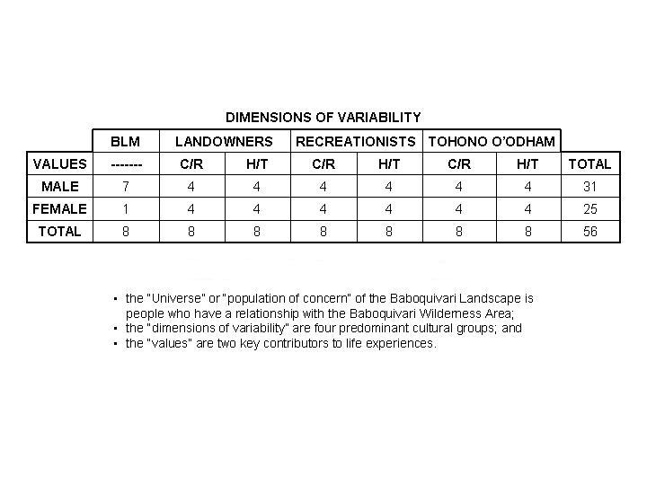
I referenced Arnold’s (1970) dimensional sampling framework of universe, dimensions of variability, and typology of values. Based on BLM records and participation at public meetings, I defined the universe, or population of concern, as landowners, recreationists, Tohono O’odham people, and the BLM. My dimensions of variability were Altar Valley landowners who occupy the valley east of the Baboquivari Mountains, recreationists from Phoenix, Tucson, and Green Valley, Arizona, the Tohono O’odham Nation to the west of the mountain range, and BLM employees from the Tucson Field Office and Phoenix State Office. For a typology of values, I selected variables of gender and knowledge base, which are two key life experiences that contribute to cultural knowledge (Gupta and Ferguson 1997, Handwerker 1998).
I determined that sample sizes of eight to 16 informants for each group were adequate (Arnold 1970, Romney et al. 1986, Handwerker 1998); the landowner, recreationist, and Tohono O’odham groups each had 16 informants, and the BLM sample was reduced to eight because not enough employees met the typology (Fig. 4). Snowball sampling allowed me to identify key informants among the landowners, recreationists, and the Tohono O’odham, whom I selected for gender and knowledge-base variables.
|
Fig. 4. Dimensional sampling framework.
|
Guided by the Tohono O’odham distinction of elder and non-elder knowledge, I determined knowledge base according to criteria regarding contact with the landscape, cognition of the landscape, and age, and placed individuals in the historic/traditional (H/T) group if they met any two of the criteria (Fig. 5).
|
Fig. 5. Knowledge base factors table.
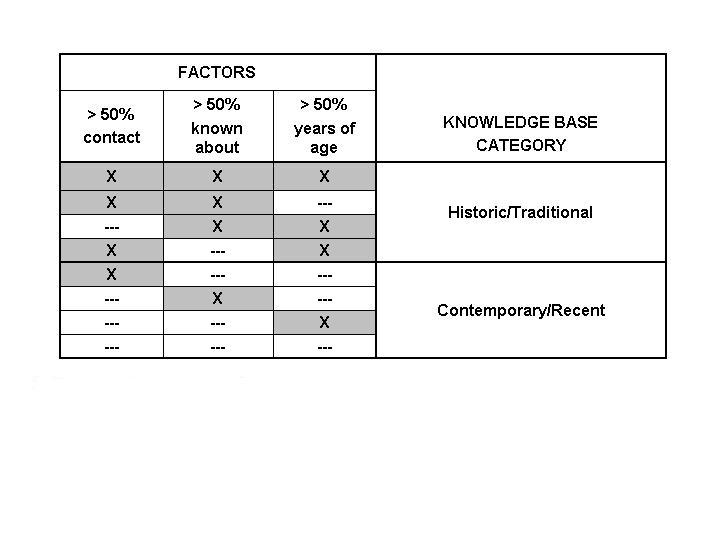
The knowledge base variable presents a particular challenge as non-scientific, lay, or local knowledge is often not accepted as valid. Two aspects of knowledge—age and contact with the landscape and resources—provide an equitable basis of recognition and validity (Austin 1998, Grenier 1998, Johnson 1992, Tuan 1974). Tuan (1974) attributes knowledge and perception at the group level to the “group’s cultural history and experience in the context of its physical setting.” According to Austin (1998), “Familiarity and experience influence the content and extent of cognitive maps.” Age and contact also provide a requisite inter-subjective definition for context and measurability of knowledge (Bernard 1995); consequently, operationalizing this variable across cultural groups. Considering direct/indirect and local/non-local parameters, I define spatial and temporal aspects of age and contact with the landscape as either contemporary/recent (C/R) or historic/traditional (H/T). I use percentages, rather than numbers, with these definitions to provide an equitable determination of each informant's knowledge base. A point of division of 50% provides a relative measure that accommodates variations in spatial and temporal aspects. This strategy balances landowner differences, such as whether one makes a living from the landscape or simply resides there, and recreational differences, such as whether an informant has been in the landscape or only heard or read about it. It also accommodates the Tohono O’odham distinction of knowledge differences between elders and non-elders.
|
Data collection
My strategy for data collection involved a triangulated, ethnographic approach of semi-structured, personal interviews held on site with key informants. Ethnographic data provide the cultural contexts within which resources are used and “thick descriptions” (Appendix 4) of human–nature relationships can complement archaeological, historical, and folklorist studies of material culture.
Triangulation can occur within a method, such as with open- and closed-response questions, or between types of methods (Denzin 1978, Beebe 1995). My “within” methods were open- and closed-response questions; the “between” methods were an interview instrument of these questions and a GIS-based map of the Baboquivari Mountain range and adjacent valleys (Fig. 6). Using these qualitative and quantitative methods of data collection, I was able to explore the parameters of the cultural landscape phenomenon in a way that provided valid numerical data (Ingersoll 1983, Fielding and Fielding 1986, Henderson 1991, Schensul et al. 1999).
|
Fig. 6. Baboquivari field map.
|
I based the interview instrument on a cultural landscape paradigm of resources identified by Indian and non-Indian people during natural and social science landscape studies (Fig. 7). In addition to these resources (plants, animals, water, archaeological features, spiritual aspects and features, topography, historic aspects and features, views, sounds, sky, and places), I included a 12th category, other features, to give informants an opportunity to identify missed resources. I also based the instrument on the premise that contested landscapes present the federal land manager with a need to make decisions on what resources are used, who uses the resources, when they use them, where they use them, and how they use them.
|
Fig. 7. Cultural landscape paradigm.
|
I then developed multiple-choice questions to obtain characterization, uses, and meanings of resources for quantitative analysis and qualitative descriptions (Appendix 5). This structure ensured systematic data collection from each informant, allowing me to reduce problems of variation within and between groups (Bernard 1995, Wilson 1996). The structure of the interview instrument allowed informants to talk about the resources in a landscape context and to the extent that they desired.
As the semi-structured interview approach is most effective when conducted under conditions most relevant to and revealing about the system being investigated (Beebe 1995), I held the interviews on site at locales chosen by each informant. I began each interview by asking each informant to complete an informed consent form that reaffirmed the purpose of my study and the informant’s willingness to participate. I then asked each informant to describe his or her relationship with the Baboquivari landscape, and to describe that landscape. We positioned the GIS-based map on the ground in front of us so that the informant could provide a graphic description of the landscape as well. I oriented each informant to the peak and our interview location, so that those who were unfamiliar with reading maps, particularly the Tohono O’odham elders, had little trouble responding. I continued the interview with questions delving into characterization, use, and meaning of each resource, asking only about those resources that the informant identified as part of his/her Baboquivari landscape.
Statistical analysisMy analysis strategy required a determination of cultural consensus before I could run t-tests to examine possible significant differences in the ways in which informants characterize, use, and assign meaning to landscape resources. I chose consensus analysis for the closed-response data because it is an established method of examining cultural data for similarities and differences, both of which are important to understanding the cultural domains being examined (Romney 1994, Kempton et al. 1997, Romney et al. 2000) (Appendix 6).
The consensus model assesses internal validity by testing for the existence of cultural consensus and the presence and basis of cultural differences (Handwerker 1998). It works with true–false, multiple-choice, and fill-in-the-blank questions, to provide estimates of informants’ cultural competence, or knowledge, and of the correct answer to each question asked of informants (Romney et al. 1986). As Baer et al. (1999) describe it, this procedure “determines whether the responses of a group of individuals indicate a “consensus” in beliefs. [It] also estimates individual respondents’ level of cultural knowledge [and] estimates the culturally “correct” answers to the questionnaire (the normative cultural beliefs) [providing] a probabilistic confidence level for the classification of each item.”
Cultural competence scores are a function of the level of agreement among individuals (Romney et al. 1986). Romney (1999) defines cultural competence as “the proportion of the cultural questions for which the correct answer, or normative cultural belief, is known by the respondent.” He does not assume competence scores to be some “truth” but rather as representative of agreement or culturally shared concepts among the informants in the sample. The estimated answer key represents a simple majority, the answers most often given (Borgatti personal communication).
Coding the responses nominally, I ran cultural consensus analyses, one-sample t-tests, and independent t-tests, and calculated scores for characterization, use, and meaning of resources by group. I began with a consensus test of the responses of all 56 informants, which confirmed the sample fit the cultural consensus model. I then ran consensus tests on the responses of each subgroup, also confirming each as fitting the model. These results allowed me to proceed with one-sample t-tests between each subgroup and the total sample, and independent t-tests between variables of the landowners, recreationists, and Tohono O’odham subgroups.
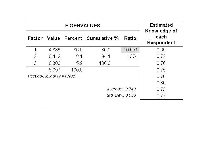
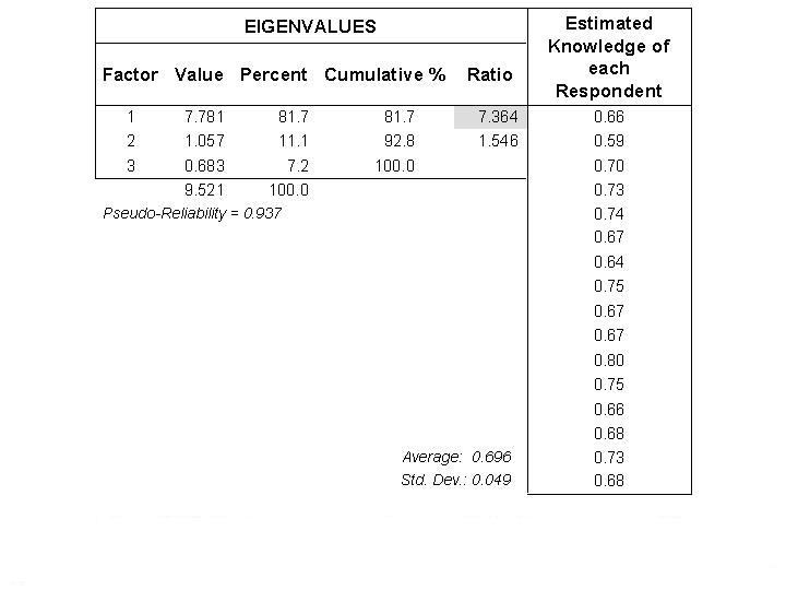
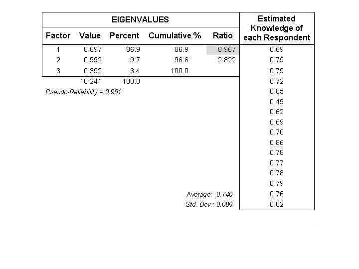
Consensus resultsThe overall group had a 7:1 ratio between the first and second eigenvalues, and a cultural competence (shared knowledge of the landscape) of 0.687 or approximately 69% (Fig. 8). The subgroup consensus tests resulted in higher ratios than that of the overall group, and knowledge scores that were equal to or higher than their respective averages within the overall results. Respectively, the ratios for the BLM (Fig. 9), the recreationists (Fig. 10), the landowners (Fig. 11), and the Tohono O’odham (Fig. 12) were 10.6:1, 7.4:1, 8.6:1, and 9:1; the knowledge scores were 74, 69.6, 69.2, and 74%, respectively. The changes in eigenvalue ratios and shared knowledge reveal different cultural knowledge domains that are nested within or overlap each other, consequently contributing to similarities and differences in landscape perceptions.
|
Fig. 8. Cultural consensus analysis results for the Baboquivari Wilderness Area informants.

|
|
Fig. 9. Cultural consensus analysis results for the BLM. As a distinct cultural consensus group, the BLM has a higher ratio and higher average knowledge than as part of the larger consensus group: ratio of 10.6 vs. 6.9, and average knowledge of 74 vs. 67%.
|
|
Fig. 10. Cultural consensus analysis results for the recreationists.

|
|
Fig. 11. Cultural consensus analysis results for the landowners. As a distinct cultural consensus group, the Landowners' group has a higher ratio than as part of the larger consensus group: ratio of 7.4 vs. 6.9, average knowledge remained the same 69 vs. 69%.
|
|
Fig. 12. Cultural consensus analysis results for the Tohono O’odham.
|
One-sample t-test results
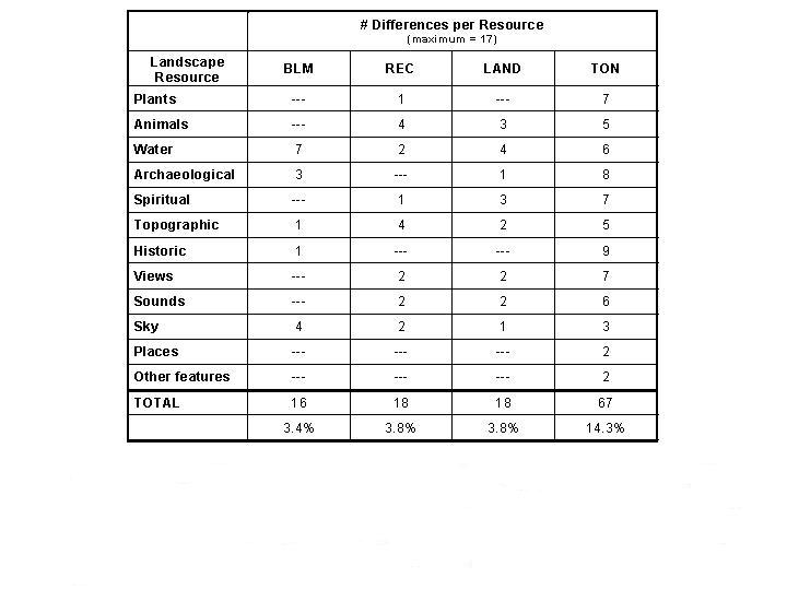
I identified specific differences pertaining to each resource by running one-sample t-tests between each subgroup and the overall sample for each of the closed-response questions. The Tohono O’odham had the most differences with 67 (14.3%) throughout 12 resources, followed by the landowners and recreationists each with 18 (3.8%) involving eight resources, and the BLM with 16 (3.4%) over five resources (Fig. 13).
|
Fig. 13. Significant differences between subgroups and the overall sample. One-sample t-test results show how subgroups differ from the overall sample in terms of which resources and to what extent. The Tohono O’odham, for example, had the most significant differences with 9 (52.9%) for historic resource. The more differences a subgroup has for a given resource, the greater the potential for conflict and less understanding on the part of the other subgroups about that subgroup's relationship with the resource.
|
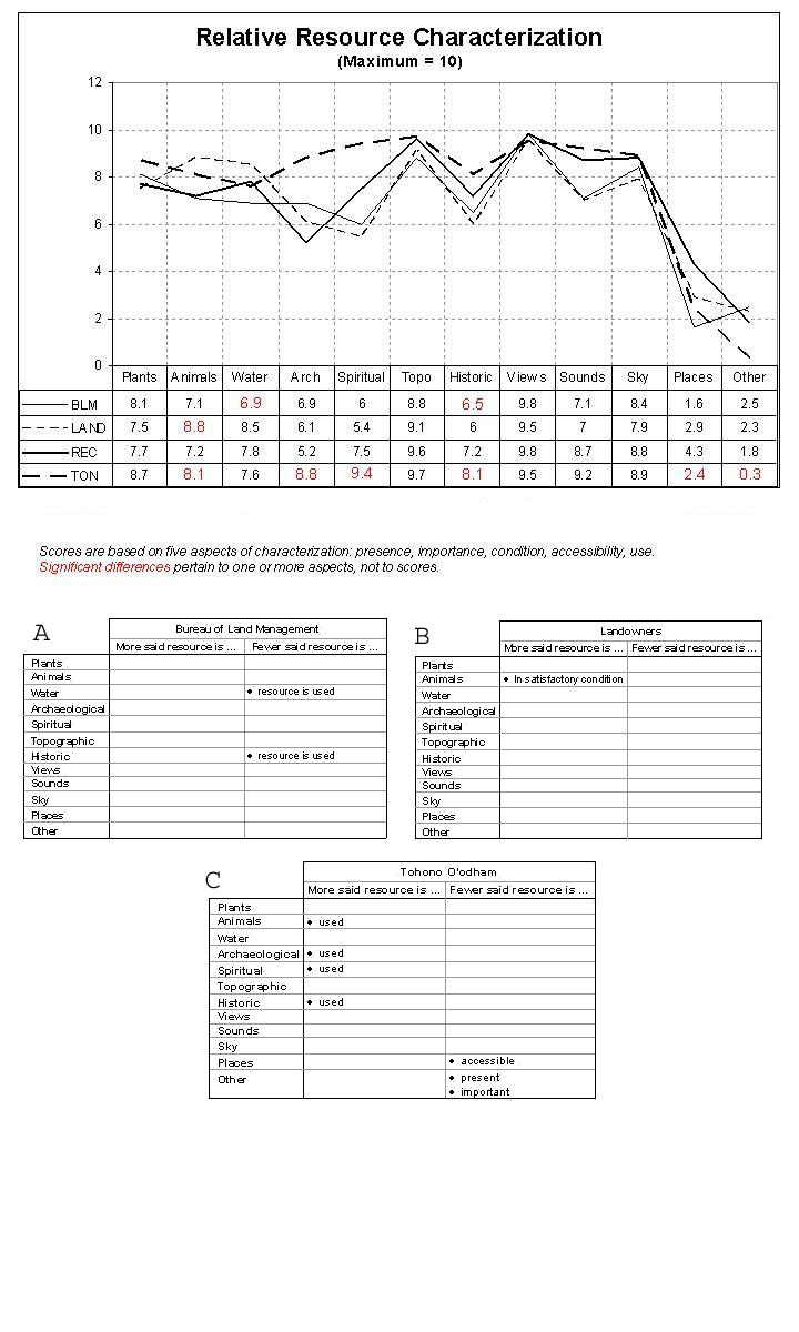
I then calculated characterization, use, and meaning scores from five to seven questions each (Appendix 5), for each resource by subgroup. The scores reflect relative levels of complexity for each group’s relationship with the resource; higher scores reflect more complex relationships and stronger group connections to the landscape. Complexities and connections not being equal, I examined the relationship between t-test results and composite scores by charting the scores and highlighting those within which a significant difference occurred in at least one of the five or seven questions constituting its score.
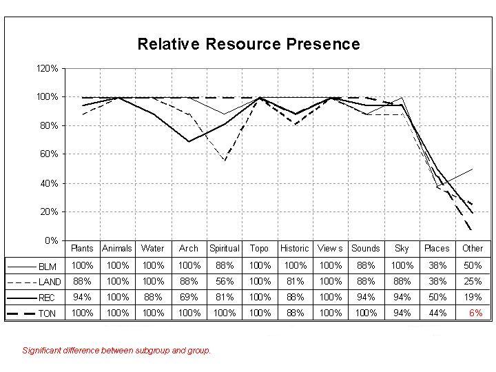
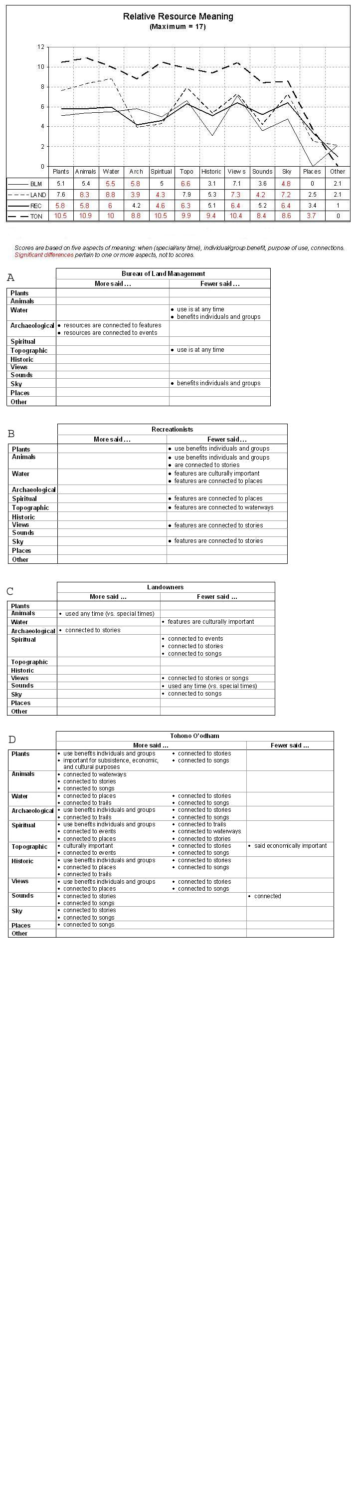
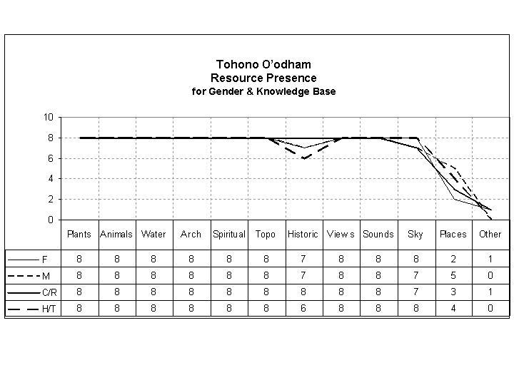
An interesting pattern of increasing differences emerged as my analysis proceeded from presence through characterization, use, and meaning, despite more questions per category. I found one difference in the presence of elements (Fig. 14), with few Tohono O’odham informants including “other features” as a distinct resource, ten differences in characterization (Fig. 15), 43 differences in use (Fig. 16), and 66 differences in meaning (Fig. 17).
|
Fig. 14. Comparison of landscape resources identified by Baboquivari informants.
|
|
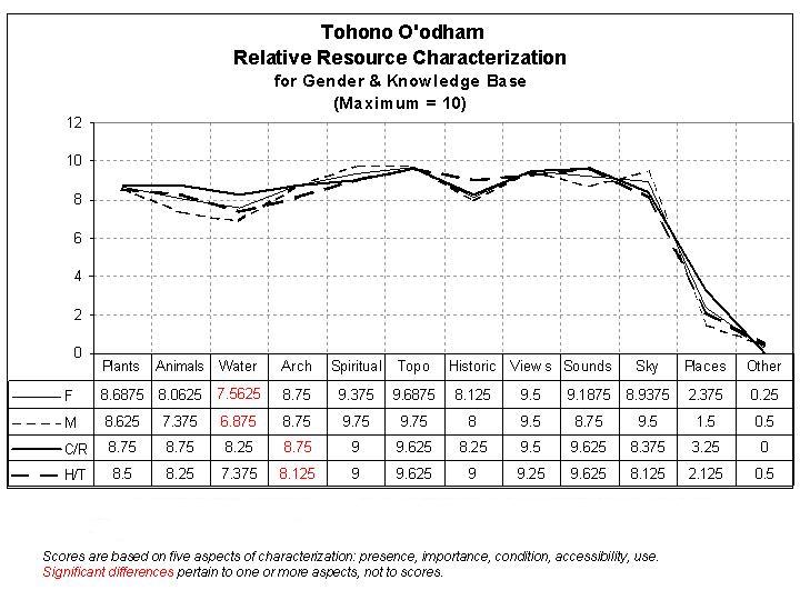
Fig. 15. Baboquivari informants’ characterizations of resources compared on a relative scale. Significant differences in resource characterizations for A) BLM, B) Landowners, and C) Tohono O’odham groups vs. the Baboquivari sample.
|
|
Fig. 16. Baboquivari informants’ uses of resources compared on a relative scale. Significant differences in resource use between A) the BLM and the Baboquivari sample; B) the recreationists and the Baboquivari sample; C) the landowners and the Baboquivari sample; and D) the Tohono O’odham and the Baboquivari sample.

|
|
Fig. 17. Baboquivari informants’ descriptions of resources’ meanings compared on a relative scale. Significant differences in resource meaning between: A) the BLM and the Baboquivari sample; B) the recreationists and the Baboquivari sample; C) the landowners and the Baboquivari sample; and D) the Tohono O’odham and the Baboquivari sample.
|
Independent t-test results
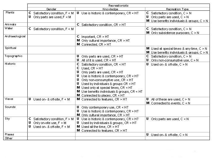
The within-group results I obtained for the recreationists, landowners, and Tohono O’odham revealed significant differences in characterizations, uses, and meanings of resources that are attributable to gender or knowledge base. Following this analysis, the question arose as to the influence of type of recreation. I found that seven of the eight men are climbers, as are two of the women. I also found that six of the H/T group are climbers and only three are in the contemporary/recent (C/R) group. Distinguishing between climbers and non-climbers, I ran additional t-tests for this variable looking for possible overlap with gender or knowledge base. As with the previous results, I have indicated significant differences by highlighting characterization, use, or meaning scores; higher scores reflect greater complexity and stronger connections to the landscape.
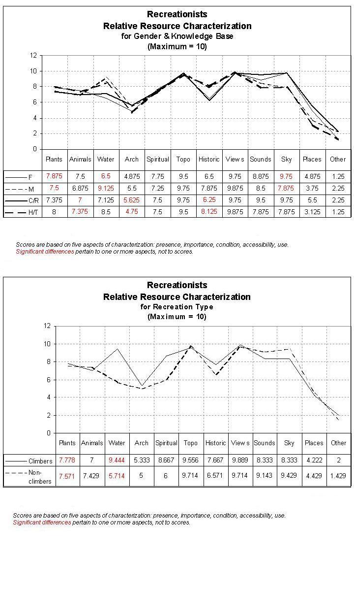
Among the recreationists, I found 44 (21.6%) differences (Fig. 18, 19, 20, 21, with the most in use, followed by meaning and characterization (Fig. 22). Knowledge base was the greatest contributor to differences in characterization, use, and meaning, followed closely by recreation type, and then gender. The only overlap in variables that I detected was for the condition of the plants and water, and whether all or part of the plants are used. Both the climbers’ and men’s groups considered plant and water condition to be satisfactory more than the non-climbers and the women, and they only use parts of the plants. As the evaluations and use involve these resources primarily during climbing treks, I suspect recreation type is the responsible variable.
|
Fig. 18. Comparison of resources in recreationists’ Baboquivari landscape.
|
|
Fig. 19. Baboquivari recreationists’ characterizations of resources compared on a relative scale.
|
|
Fig. 20. Baboquivari recreationists’ resource use scores compared on a relative scale.
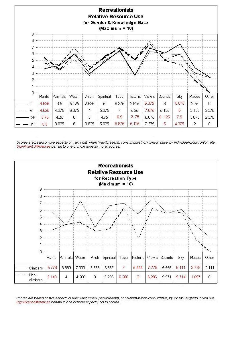
|
|
Fig. 21. Baboquivari recreationists’ resource meaning scores compared on a relative scale.

|
|
Fig. 22. Recreationists’ differences in Characterization (C), Use (U), and Meaning (M) attributable to gender (female (f), male (m)) or knowledge base (Contemporary/Recent (C/R), Historic/Traditional (H/T)).
|
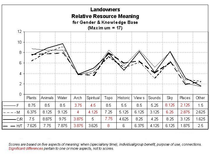
Of the 29 (14.2%) differences that I found among landowners (Fig. 23, 24, 25, 26), most occurred in meaning, followed by use and characterization (Fig. 27). The characterization and use differences were more attributable to gender than to knowledge base, but more of the meaning differences were due to knowledge base.
|
Fig. 23. Comparison of resources in the landowners’ Baboquivari landscape.

|
|
Fig. 24. Baboquivari landowners’ characterizations of resources compared on a relative scale.

|
|
Fig. 25. Baboquivari landowners’ resource use scores compared on a relative scale.

|
|
Fig. 26. Baboquivari landowners’ resource meaning scores compared on a relative scale.
|
|
Fig. 27. Landowners’ differences in Characterization (C), Use (U), and Meaning (M) attributable to gender (female (f), male (m)) or knowledge base (Contemporary/Recent (C/R), Historic/Traditional (H/T)).
|
I detected only 14 (6.8%) differences (Fig. 28, 29, 30, 31) among the Tohono O’odham, with gender having more impact on resource use and meaning (Fig. 32). Both variables contributed equally to differences of characterization.
|
Fig. 28. Comparison of resources in the Tohono O’odhams’ Baboquivari landscape.
|
|
Fig. 29. Tohono O’odhams’ characterizations of Baboquivari landscape resources compared on a relative scale.
|
|
Fig. 30. Tohono O’odhams’ use scores of Baboquivari landscape resources compared on a relative scale.

|
|
Fig. 31. Tohono O’odhams’ meaning scores of Baboquivari landscape resources compared on a relative scale.

|
|
Fig. 32. Tohono O’odham differences in Characterization (C), Use (U), and Meaning (M) attributable to gender (female (f), male (m)) or knowledge base (Contemporary/Recent (C/R), Historic/Traditional (H/T)).
|
For the most part, consideration of effect size indicates that the sample sizes of eight to 16 for the between-group analyses, and of four to eight for the within-group tests are adequate. At a confidence level of .95, only six informants with average knowledge of 0.7 are needed to achieve correct answers 95% of the time, and only four informants are needed to achieve correct responses 85% of the time. A few exceptions occurred in the BLM responses, suggesting a possible inadequacy of the BLM sample size of eight for the questions involved. This finding illustrates the advantage of the effect size–significance evaluation by pointing out specific questions that may require further investigation. The possible inadequacy of sample size is limited to these few cases, and does not apply to other BLM responses, nor to the other groups. Additionally, the questionable results involved acceptance of the null hypothesis rather than rejection of it. Greater differences, however, may exist between the agency and the other three groups.
Based on established estimates (Romney et al. 1986, Handwerker 1998), the reliability and validity of the results are quite high. Sixteen informants with an average level of agreement of 0.7 have an estimated reliability of 0.97 and a validity of 0.99; eight informants with the same level of agreement have a reliability of 0.95 and a validity of 0.97, and four informants have a reliability of 0.90 and a validity of 0.95.
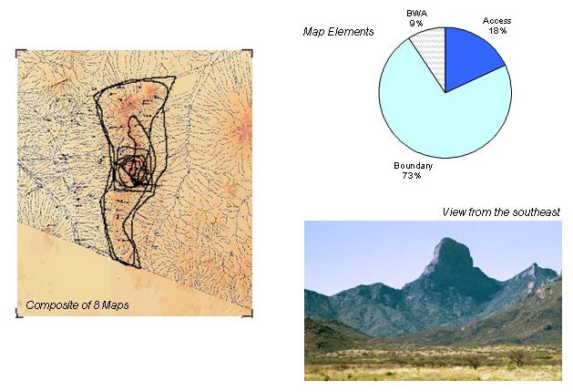
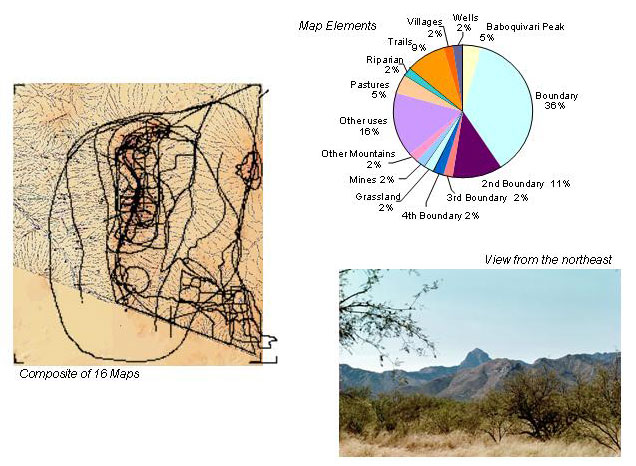
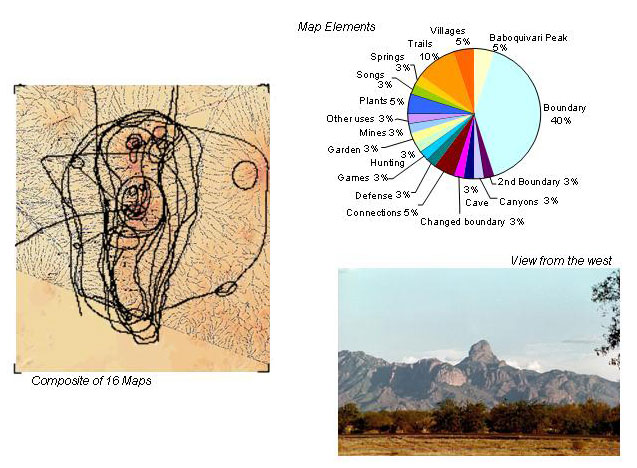
Map dataWhen I asked the informants to describe the Baboquivari landscape on the GIS-based maps, I began by orienting them to our interview site and Baboquivari Peak. From these points, they began marking features, trails, use areas, and other details that define their landscape. Although the data are concentrated on the mountain range, these extend to the boundaries of their landscapes. Consolidating informants’ maps into group maps, I determined that the landowners and Tohono O’odham have more detailed and complex landscapes than the BLM and recreationists. I noted three details (Fig. 33) for the BLM, 11 for the recreationists (Fig. 34), 14 for the landowners Fig. 35), and 18 for the Tohono O’odham (Fig. 36). I also found group-specific emphases, which include the wilderness area for the BLM, the Altar Valley watershed for the landowners, access and the peak for the climbers, and Baboquivari Peak and its associated viewshed, which includes most of southern Arizona and northwest Mexico, for the Tohono O’odham.
|
Fig. 33. The BLM’s Baboquivari landscape mapped and detailed, with a common view.
|
|
Fig. 34. The recreationists’ Baboquivari landscape mapped and detailed, with a common view.

|
|
Fig. 35. The landowners’ Baboquivari landscape mapped and detailed, with a common view.
|
|
Fig. 36. The Tohono O’odhams’ Baboquivari landscape mapped and detailed, with a common view.
|
I detected a positive correlation between spatial and temporal aspects of the subgroups’ maps. Spatially, the BLM has the fewest details in the smallest landscape, followed by the recreationists, the landowners, and the Tohono O’odham. The temporal aspect of the subgroups’ maps has to do with their respective histories or relationships with the area. The BLM has been in the landscape for the shortest period, with its management responsibility beginning 40 to 60 years ago. The recreationists’ claim a 105-year history that began in 1895 when Robert Forbes made the first documented ascent of Baboquivari Peak. The landowners date their group by the multi-generational ranching families in the Altar Valley and consider their history to range from 150 to 300 years. The Tohono O’odham informants identify a relationship with the landscape since “time immemorial.” Although anthropologists debate what this means, at least one noted archaeologist has documented detailed evidence of cultural remains in the nearby Pinacate area that date back more than 40 000 years (Hayden and Dykinga 1988). A local, informal consensus of 10 000 years is less controversial, however, we can say irrefutably that it is at least 500 years since the first European presence in the area was documented, approximately in the mid-1500s.
Qualitative dataEach informant provided qualitative data throughout his or her interview, which give life to the preceding results. Their narratives serve as portals to their relationships with the landscape, and provide insight to the roles of specific resources.
From the BLM informants, I heard first a managerial response about their relationships with the landscape that often was followed by a personal response (Appendix 7). As an agency, the BLM’s relationship with the Baboquivari focuses on resolving multiple, conflicting demands within the context of mandates and policies. As individuals, informants struggle with reconciling their professional responsibilities with their personal ethics.
I heard from the recreationists concerns that center on access to the wilderness area for hiking, climbing, and respite, as well as concerns about the possibility of increased use should access improvements become part of the wilderness plan (Appendix 8). It is the rock climbers, however, who experience the area in ways difficult to comprehend without having gone one-on-one with the peak. They respect the spiritual nature of the peak and experience it more intensely with each climb; the power of the mountain encompasses them without relief until they return to the base. This is the attraction, the spirituality and the power; not a desire to conquer nature. I also found that the power is not limited to the peak, although it is concentrated there. As the climbers retreat from the intensity of their experience, back through ecological zones to the built environment, they bring some aspect of that power with them. All the recreationists expressed similar feelings of renewal that nourishes them until their next opportunity to visit Baboquivari.
“It’s home.” Repeatedly, the landowners told me how the Baboquivari landscape, the mountain range, and its sentinel of a peak dominate the lives of those who live in Altar Valley (Appendix 9). It is a source of reassurance, information, pleasure, and spiritual feeling, and can be seen from practically every corner of the watershed, providing a bearing for anyone who looks beyond the roadways or trails in the valley. Wherever residents may be returning from, be it Puerto Peñasco, Mexico, the Santa Cruz Valley, Tucson, or Phoenix, whether by car or airplane, the peak is what they look for and when they first see it, no matter how far away, they know they are home.
The Tohono O’odham informants told me that, at one time, all the O’odham villages throughout the traditional lands had a view of Baboquivari Peak; everyone knew what it was and what it meant. They see this as explaining how the Baboquivari landscape is O’odham and the O’odham are the Baboquivari landscape. They describe their relationship as involving prayers, guidance, spirituality, identity, moral lessons, teaching, learning, and personal and cultural survival. It is infused and sustained through resource uses such as plants and animals for medicines, food, clothing, and tools, through kinship, ceremonies, stories, songs, prayers, and legends (Appendix 10).
When they have lost touch with the O’odham that is self, they return to Baboquivari to seek advice and to regain their identity through interaction with the mountain and I’itoi. It is where tribal leaders and elders seek strength and guidance to help their people. Individuals also turn to Baboquivari when some experience, such as military service or alcoholism, leaves them feeling lost and out of touch with themselves, family, and friends. They remember the traditional relationship and return to Baboquivari, sometimes spending several nights there alone and in contemplation. Always they return with a restored sense of identity and purpose, sometimes giving their lives to their people to help them overcome today’s challenges.
Many O’odham believe that their culture is dying and that the younger generations are not interested in the traditional ways because they have lost much of that relationship through the past 100 years of impacts from government agencies and religious institutions. They know, however, that as long as Baboquivari and the O’odham people exist, it is possible to rebuild that relationship.
All the informants have some awareness and a general understanding of the importance of the landscape to the other subgroups and to stakeholders outside the sample of this study. It is a management area, for example, to the BLM, a vista and recreational retreat for recreationists and some landowners, a livelihood for local ranchers, and a sacred site to the Tohono O’odham. For the Arizona Game and Fish, and the U. S. Fish and Wildlife Service, it is a wildlife management area; for the U. S. Border Patrol, a corridor used by illegal immigrants and drug smugglers; and for the military, Border Patrol, and Pima County Sheriff’s Department, a flight path. Beyond this general understanding, however, lies the substance of each group’s relationship with the Baboquivari Wilderness Area.
At their most generalized, the results indicate that management decisions for an isolated 2065-acre wilderness will have direct and meaningful impacts throughout a much larger area that is bounded by Tucson, Phoenix, and Green Valley, Arizona, Pozo Verde, Mexico, and the Sea of Cortez. In practical terms, the results indicate that each group brings significant filters to the public forum.
The BLM is guided by natural sciences, special interests, and legislation. It makes minimal use of and has minimal physical contact with the land and resources. Recreationists seek healthy ecology, biodiversity, and pristine conditions. They emphasize individual well-being and are hobby oriented. The landowners prefer to apply their knowledge of the land and resources. They are economic and production oriented, and they emphasize family and community in their landscape. The Tohono O’odham view the land and people as one. They engage in reciprocal relationships with the land and resources, and know they have responsibility to care for the land. Considering relationships within the results, I found implications for management, use of the public forum, and the original research problems.
ManagementThe consensus results illustrate the relationship between different bodies of knowledge (Fig. 37). The agreement of the overall group reflects the shared perception of the public forum while subgroups maintain distinct landscape knowledge and perceptions that have some overlap with the public forum. The shared knowledge of the overall group is composed predominantly of presence and characterization of resources. Within the subgroups, shared knowledge includes, in addition to these parameters, uses and meanings.
|
Fig. 37. Relationship of individuals’ landscape perception to cultural and public forum perceptions.

|
The different layers of consensus illustrate the advantage of examining subgroups separately from the overall group. Additional interaction between the agency and each subgroup outside the traditional public forum has the potential to significantly enhance the agency’s understanding of cultural issues and the group’s understanding of agency issues.
Examination of between-group differences and within-group differences reveals little overlap. The landowners, for example, differ from the overall group regarding connections between the spiritual resources and events, stories, and songs. Within-group, however, the women indicated much use and many details of use. The men in turn were reluctant to acknowledge or discuss spirituality as part of their landscape. Discussion with the women about their families’ relationship with the landscape suggests otherwise, that the landscape in fact holds a great spiritual component for the men as well. The lack of discussion or acknowledgment of this resource by the male landowners may lead others to believe that these men view the landscape as nothing more than an economic base. Impassioned disagreement that may arise between the landowners and others in the public forum may be attributable to this aspect of the landowner relationship with the landscape, but because it is unvoiced, other reasons may be assigned that do little to improve the situation (Appendix 11).
Between-group differences for the landowners and recreationists, which are concentrated in uses and meanings, are fewer than their within-group differences. The latter may have less significance or pertinence to management but remain important in that they help explain some of the differences that occur in the public forum. By recognizing and considering the perspectives of men, women, those more experienced with the landscape, and those less so, the agency gains a deeper understanding of the cultural issues and potential impacts of and responses to its decisions.
The Tohono O’odham, however, have many more between-group differences than within-group differences; most of the latter are attributable to gender and most occur in meanings. This finding confirms a level of cultural continuity that reflects gender-specific traditional knowledge. From a management standpoint, these within-group differences may be quite pertinent as O’odham men and women continue to honor and practice their respective relationships with and responsibilities for the landscape.
I had anticipated more knowledge-base differences among the Tohono O’odham informants than I obtained, however, as I reviewed the dates of the interviews, I found that most of the interviews with elders were not held during the winter months. The Tohono O’odham believe the winter months are the safe and appropriate time to tell stories because the snakes are hibernating and will not be a danger to people; consequently, as they were interviewed outside of the winter months, their responses were limited in detail.
The pattern of increasing differences through categories, from presence in the landscape to general characterizations, aspects of use, and meanings that are associated with the resources, takes on more meaning when considered with the spatial and temporal correlation of the map data, that between the size and details of each group’s landscape, and the “age” of each group’s landscape. Assigning an age to a cultural landscape is possible because such landscapes represent perceptual and physical relationships between humans and nature that take time to develop; the pattern of increasing differences noted above suggests a process by which this development may occur.
The BLM group then, has the youngest, smallest, and least detailed landscape, within which they emphasize management. The recreationists, with the next youngest landscape, have more details and a broader landscape; they emphasize access, recreation, ecology, and connections. The landowners, with the next oldest landscape, have even more details and broader landscapes. They emphasize multiple boundaries, communities, habitats, topography, and multiple uses. The Tohono O’odham, with the oldest and broadest landscape, and the most details, emphasize multiple boundaries, communities, cultural use areas, topography, connections, and song trails. The latter finding is of particular interest because people who are inexperienced in reading maps are not expected to provide much information. I believe this finding reflects the capacity of the Tohono O’odhams’cognitive maps, their cultural models, of the landscape.
The relationship between the interview data and the map data is one in which the graphic informs the narrative and vice versa. From individual responses, group perceptions are identified; from individual mental models, cultural models are revealed. Landscape resources are described by aspects of characterization, use, and meaning, then given a geographic basis of interactions, which grounds the relationships of the people with the land. Use areas and multiple landscape boundaries identified on the map also indicate the potential for much broader impacts from management decisions, and the interview data elucidate details about those impacts.
Overlaying the graphic descriptions for the four groups reveals a mountain range of layered cultural landscapes. As a place where different cultural relationships are concentrated, the Baboquivari Mountains represent both conflict and accord. The data enhance our understanding of what and where these are and, from this understanding, topical and physical areas of conflict can be clarified and opportunities for cooperation can be identified.
How can land managers use this information in planning and decision-making? Given the agency’s limited use of the resources, it provides them with a way to better understand local landscape relationships and the reasoning behind cultural priorities assigned to landscape use. Rather than trying to respond to individual demands, the agency can substantiate a decision to respond to and use a cultural group’s local knowledge over that of a single voice, when considering both is not possible.
The results also provide support for incorporation of local knowledge in the planning and decision-making process. This is more than the ethically desirable goal voiced by some BLM informants. When local, indigenous, and scientific knowledge systems are combined, they inform and stimulate each other, consequently providing the best chance of sustainable natural resource use and management (DeWalt 1994).
Public forum and the ethnographic approachDuring public meetings, landowners, recreationists, and Tohono O’odham people met with the BLM to identify and rank issues and concerns about management of the Baboquivari Wilderness Area. The participants realize, however, that a body of obscure knowledge remains unaddressed; much of this information is inaccessible in the public forum because of the sensitive or deeply personal nature of the cultural issues.
Although the meetings provided limited information about social concerns, cultural issues, and potential impacts from management decisions, the results of this research enhance understanding of some issues, and reveal significant concerns not brought out in the public forum. The results overlap with and contextualize three concerns from the public forum: access, management, and sacredness (Fig. 38).
|
Fig. 38. Overlap of cultural concerns identified through public forums and ethnographic interviews.

|
In the public forum, for example, access is identified as a concern of the recreationists, and is assumed to mean physical access for hiking, climbing, bird watching, etc. In the interviews, however, I found access to be a need of both recreationists and the Tohono O’odham; it supplies the recreationists with spiritual renewal and escape from urban pressures, and it provides the Tohono O’odham with physical and spiritual renewal, connection to the “truth,” hope for continuance of their culture, and a means of teaching traditions to the youth. The agency now has more cultural knowledge to aid decision-making within the context of such diverse mandates as the Wilderness Act (1964), the American Indian Religious Freedom Act (1973), the Native American Graves Protection and Repatriation Act (1990), Executive Order 11593 (Protection and Enhancement of the Cultural Environment) (1971), Executive Order 13007 (Sacred Sites) (1996), and Executive Order 13175 (Consultation and Coordination with Indian Tribal Governments) (2000).
As another example, the Tohono O’odham people speak of the sacredness of the mountain and the peak at public meetings. Some have related abbreviated versions of how they felt lost when they came home from war and how they turned to the mountain for help. Away from the public forum, these individuals and others launch into discussions of plants, animals, medicines, ceremonies, and family that seem tangential at first but soon reveal the web within which sacredness and the meaning of sacredness is held. Within the same account, however, the youth are brought into the picture. They do not have the traditional foundations that the elders and other adults retain, nor do they seek such knowledge and philosophy. The traditional people are at a loss as to how to get through to the youth before it is too late and more of the culture is lost to the next generation. Were they to feel less constrained by outside forces that have some control over Baboquivari, they could pursue the traditional lessons, the passing on of knowledge in the appropriate setting and with the appropriate state of mind.
The original research problemsFederal land managers are hindered in their efforts to respond effectively to the diverse public they serve by a lack of cultural knowledge and of a systematic way to obtain it. At the planning level, where the brunt of resource management conflicts are felt, the federal resource manager faces specific challenges of natural and cultural resource management issues (Juen personal communication, Walker personal communication):
- Field staff at all levels lack adequate knowledge and understanding of cultural issues that would allow them to do a better job;
- Field staff at all levels lack skills, patience, and tolerance to work with local people or groups of diverse people;
- Managers lack of a consistently effective way, including quantifiable methods, to combine multicultural values and concerns with current management tools and concepts for decision-making;
- Personnel may consult but find it difficult, with their current level of understanding, to incorporate Native American concerns, issues, and needs into decision-making; for example, statements like “it is important, sacred to us” do not provide enough information for the manager to make an appropriate decision about where to site a mining operation;
- Field staff at all levels lack knowledge and understanding of the uniquely federal relationship of tribes and federal agencies, of sovereignty, government-to-government relationships, and trust responsibilities.
The results of this research address these issues by providing new knowledge pertinent to wilderness management decisions, and by enhancing knowledge obtained through the public forum. The methodology, from sampling to data collection and analysis, provides a consistent strategy for obtaining cultural knowledge. The results also show how and to what degree the importance and value of landscapes to different cultural groups can be described. The potential benefits of this research to the BLM in its planning for the Baboquivari Wilderness Area include (Juen personal communication):
- the ability to write a plan that incorporates cultural concerns with BLM decision-making strategies to effect an integral conservation of social and natural systems;
- a learning opportunity for BLM employees;
- an opportunity to inform the general public of cultural concerns without unnecessarily revealing sensitive cultural information;
- placing the BLM in a better position to mitigate existing and anticipated conflicts;
- a way to identify and incorporate diversity for more equitable management responses to the needs of diverse cultural groups; and
- an opportunity for stakeholders to learn about the concept of cultural landscapes and its potential as a natural resource management tool.
The methodology is applicable at the field-office level. Compared with current methods of gathering cultural information, some training in ethnographic techniques and analysis may be required, however, agencies already employ social scientists, and have GIS technology, databases, and spreadsheet software to conduct the mapping and analysis. The time required to implement this methodology is comparable to the time frames of current methods, and just as dependent upon the public response to a given planning activity.
As the methodology is based on human–nature relationships from which cultural landscapes develop, it has broad applicability in situations matching the case study criteria of this research. The results, however, are not transferable to similar situations because Baboquivari is a wilderness area, which raises different values than non-wilderness areas. Each new case will be as individual as its landscape and population of concern, and will produce its own unique findings. The Montana rancher with a Scandinavian heritage, for example, will have a different landscape than the Colorado rancher with a German heritage. So too will the Lakota Sioux have a different relationship with their landscape than that of Western Shoshone tribes.
It should be noted as well that this study was limited to the predominant interest groups who have maintained communication with the BLM regarding the Baboquivari Wilderness Area. Other federal agencies, state agencies, and environmental organizations may have interest in the area, yet, having not interacted with the BLM directly or through the public forum, they remain wild cards in the BLM’s planning process. This research, therefore, represents a significant advance in the BLM’s understanding of the more vocal interests in the Baboquivari Wilderness Area, rather than a panacea.
An additional benefit of this methodology is its potential to improve federal agencies’ relations with the public. On-site interviewing, as conducted with the participants in this study, provides an informal and neutral ground conducive to an enjoyable learning experience for both parties. This benefit will become increasingly important as our population increases, and as environmental and political interests continue to complicate land uses and management.
Although the public forum has a legislated basis and role, the ranking of issues is more an artifact of that social environment than a reliable reflection of social and cultural issues. Consensus of the overall group, and through the public forum in the form of prioritized issues, differs from consensus of each cultural group as identified through systematic social science. The two levels of agreement have some overlap, however, significant differences exist between the two, and cultural consensus within each subgroup, as it represents agreement and shared knowledge, is greater than overall group consensus. Subgroup consensus and knowledge are useful to the federal manager in that these can inform and enhance public forum rankings, and aid the BLM’s negotiation of differences.
Responses to this article are invited. If accepted for publication, your response will be hyperlinked to the article. To submit a comment, follow this link. To read comments already accepted, follow this link.
My research would not have been possible without the guidance and support of my committee: Dr. H. R. Gimblett, Dr. W. W. Shaw, Mr. M. D. Johnson, Dr. R. W. Stoffle, and Dr. J. S. Lansing. The openness and enthusiasm of the BLM Tucson Field Office for this project was most gratifying. Documents from this office and the BLM Phoenix State Office were instrumental to understanding the management history of the Baboquivari Wilderness. I am indebted as well to the Altar Valley landowners, the recreationists, and the Tohono O’odham Nation and members who participated in this study, and thank them for sharing their landscapes.
APPENDIX 1. The Unique Status of Native American Tribes in the United StatesThe Tohono O'odham, as do all federally recognized tribes, have special rights and privileges over other interested groups. They have special legal status as dependent sovereign nations, with the federal government holding their lands in trust although these lands, at the same time, are subject to management and use by tribal councils and the Bureau of Indian Affairs. Federal legislation provides additional protection of religious freedom rights, cultural resources including human remains, sacred sites, and government-to-government relationships.
The government-to-government relationship is rooted in tribal sovereignty, dependent nation status, and the federal government’s trust responsibilities to American Indian tribes.
The U. S. government has a unique and special trust responsibility to federally recognized Indian tribes as established by treaties, statutes, court decisions, and the U. S. Constitution...tribes should not be considered “interested parties” because of their sovereign status...there are cultural differences and similarities frequently seen when tribal and nontribal participants meet (see Wax and Thomas 1961).Some of the more common differences include the relative concept of time, the role of consensus decision-making, trying to control and profit from the environment, and the connection of religion and other traditional aspects of culture to the environment (Russo 2000). (Stapp and Burney 2002)
The National Historic Preservation Act (NHPA) of 1966 (Public Law 89-665, as amended by Public Law 102-575), National Environment Policy Act (NEPA) of 1969 (42 U.S.C. § 4321-4347), American Indian Religious Freedom Act (AIRFA) of 1973 (42 U.S.C. § 1996), Archaeological Resources Protection Act (ARPA) of 1979 ( 16 U.S.C. 470aa – 470mm), and Native American Graves Protection and Repatriation Act (NAGPRA) of 1990 (Public Law 101-601) require federal agencies to consult with tribes on a government-to-government basis.
The laws that provide for public participation in resource management contrast this relationship. The NHPA allows groups to contact agencies and apply to be recognized as an interested party for management of resources at a given place. The NEPA allows anyone to submit comments regarding management of resources at a given place to an agency during the decision-making process (Stapp and Burney 2002).
Other legal protection of Native American interests can be found in presidential executive orders, proclamations, and memorandums; federal regulations; and agency-specific management policies and directives:
Executive Documents
Executive Order 11593. Protection and Enhancement of the Cultural Environment. (May 13, 1971, 36 FR 8921).
Memorandum on Government-to-Government Relations with Native American Tribal Governments, April 29, 1994, 59 FR 22951 [25 USC 450].
Executive Order No. 13007. Protection and Accommodation of Access to Indian Sacred Sites. May 24, 1996, 61 FR 26771 [42 USC 1996].
Executive Order No. 13175. Consultation and Coordination with Indian Tribal Governments. November 9, 2000, 65 FR 67249 [25 USC 450].
Presidential Memorandum entitled “Government-to-Government Relations with Native EO13084 (1994) Consultation and Coordination with Indian Tribal Governments (63 FR 27655)
Federal Register 1995, 9250-9255.
Bureau of Land Management (BLM) policies.
Federal Land Policy and Management Act (FLPMA) of 1976 (Public Law 94-579; 90 Stat. 2743; 43 U.S.C. 1701)
National Forest Management Act (NFMA) of 1976 (16 USC 1600 et seq.)
8100 Series “Protecting Cultural Resources, 8100 Series – Interim Guidance.” References include (Bureau of Land Management 2000):
- National Programmatic Agreement of March 26, 1997;
- Title 36 Code of Federal Regulations, Parts 60, 61, 63, 65, 68, and 800;
- Title 43 Code of Federal Regulations, Parts 3 and 7;
- 8110–Identifying Cultural Resources, and H-8110–Guidelines for Identifying Cultural Resources;
- 8120–Protecting Cultural Resources, and H-8120–Guidelines for Protecting Cultural Resources;
- 8130–Utilizing Cultural Resources for Public Benefit
- 8160–Native American Coordination and Consultation, and H-8160-1–General Procedural Guidance for Native American Consultation
The concerns of the Tohono O’odham include ecological and cultural issues. They explained that medicine plants, once abundant around Baboquivari Peak, are hard to find today and that, although spiritual features and aspects are accessible at all times from all places, they are more intense and effective in the area of the peak. Increased recreational activities on both sides of the mountain range interfere with ceremonial and ritual practices, and the passing on of cultural and ecological knowledge, which require specific environmental conditions. The connectivity and widespread benefit of use they described are interdependent aspects of a long-term relationship with the landscape, which they feel is essential to landscape health. Their use of the landscape and resources is necessary to sustain that relationship. Frequent references were made to personal and group responsibility, as assigned by the Creator, to care for the landscape and everything it encompasses. Informants explained how the condition of the elements, although satisfactory, could be improved if the Tohono O’odham people could fulfill their responsibilities.
Their feeling of other places being inaccessible reflects an impact of their historic relationship with non-Indians during which they lost most of their traditional territory. As those with the oldest cultural landscape, the oldest relationship with the Baboquivari, the Tohono O’odham feel the most constrained and restricted, suggesting that the older a cultural landscape, the more difficult it is for the people to distinguish themselves from the land.
The Baboquivari landscape is a people, a culture, a tradition.
The Baboquivari landscape is the home of the creator, I’itoi. I’itoi gives us everything to survive. It’s up to the individual to take care of it. It is a sacred place of power and strength that traditionally was only for medicine men. It’s very, very important. That’s because I’itoi made the mountain, and lived here; this is I’itoi’s home.
It’s something that’s very important to the O’odham people because it’s made from the earth and we’re made from the earth as well and it’s an everlasting thing. It’s very spiritual, like when a child is born, they’re, at a certain age, like months, they give them the mud, and that’s what strengthens the heart and the soul and the whole body. And that’s how we used to baptize our children before the missionaries came. Gave them their O’odham name. To this day, some medicine men will still give a child an O’odham name. Usually it’s something that’s, happened around here, the blossom [of the banana yucca]; some of her grandchildren are One That Meets the Wind, Bright Star, Ebony Star.
Her grandfather was the caretaker of the whole mountain. He was like the king of the medicine men. When the cabin and park were built by the CCCs in 1933, they did not tell her grandfather. When he found out, he got sick. He died in 1937, never recovered from the sickness.
Through the legends. When I was going to school here, I got to know what Baboquivari is about and my mom’s uncle taught us the legends about the mountains, he told us stories about what is up there and why it is there, but it’s summer and it’s not right; I still see rattlesnakes out here and that’s one of my beliefs.
The women’s relationship has really, really changed. They can go up here now. Some go up to the cabin, go up to the peak, come here [the campground] and, people come here if they’re, you know, people that still make baskets come into the area and pick up yucca and beargrass for their baskets. In 1940, when they had the first annual gathering here after they had built the cabin, she went up there, she made an offering. They told her to put whatever she thought, like pinole. She started making flowers then and she took them up there and asked I’itoi to help her, that from then on she would be making flowers for anybody that wanted. Different people go up there for different reasons but hers was to make flowers. The flower is like a song to her. Once she starts making it, it keeps going round and round and before you know it, she’s finished. It’s beautiful. When the song is done, the flower’s done. She’s even tried to demonstrate to the elders at the Elderly Program how she does it. And they can’t, they can’t do it. She sings while making the flower. You can’t make a flower without a song. It’s a very special gift from I’itoi. Now she doesn’t have problems with her hands or her fingers. Her arms and hands are good now.
She’s climbed up to the cave several times and one time in the cave. When she went over there to go in the cave, she had some second thoughts when she saw that hole and that it was really small. And she tried to go in and had to adjust her shoulder to go in the cave. Finally, she went in and walked around inside and saw the opening, that it was real small, and she wondered what would happen when she came out. And when she did come out, her mind, her thoughts had composed themselves to where she was able to think clearly to come back out; again she kind of had a hard time with her shoulders. She didn’t just go in, she was talking to the person that lives there, she went in and all her thoughts were at the same time communicating with the spirit. And once she came back out, they started coming back down. When she went home, she told her family and they didn’t believe her. But she said it didn’t matter because she’s been there and she’s seen it. She knows what it all is.
The Baboquivari landscape, beginning at the peak, extends as far as the peak can see and be seen. It is connected to places in Arizona and Mexico that are remembered today through rituals, ceremonies, stories, and songs. The Salt Trail to the Sea of Cortez is a direct link between the mountain and the sea, one that hints at the significance of seeing the ocean from the peak, one that is sustained through traditional ways including stories, songs, and ceremonies. When the O’odham men traveled the Salt Trail, they would come from all over the traditional lands to the west side of the peak near the cave and gather before traveling to the sea. Just as the men who recently walked to Baboquivari from the sea, these men sustained themselves and survived their journey with strength and through songs from the mountain. Baboquivari is their source of life and survival, and has remained so through Spanish intrusions, Apache raids, settler encroachment, federal policies that have done more to divide than protect, and the establishment of a wilderness area.
Her grandfather told them that at different times, different people, some people would go up there and go inside the cave and the opening would close up for some reason. And they have to sing songs or maybe they didn’t bring an offering or maybe they spiritually, traditionally, culturally they weren’t prepared to go up there. And they would and then this would happen. Her grandfather used to tell them that you have to go up there with a clear mind spiritually, physically, to make it up there and come back, leave an offering. Certain people don’t have any problem going in there but when they get in there, it sort of, the opening sort of narrows down and they can’t get out. Just the other day when we were here, this guy was telling me that he went in but he almost couldn’t come out. It was so easy for him to go in and then it was hard for him to get out. And he just had to pry himself out of there. For some reason, maybe they don’t believe in it or whatever reason. If it wasn’t meant for you to go in, that hole would narrow itself to where you can’t go in. But if it was meant for you to go in there, then you can just slide in and slide out.
The other thing that she mentioned is the wind that lives up there somewhere up there. Once in a while it’ll come out, the wind will blow and purify the whole area and that’s how everything went right with everybody. The wind would purify the rest of the air. And the cloud that she mentioned also that was up there somewhere and once in a great while when there’s need for rain, it would come out and rain and just give the earth a lot of water and it would turn, uh, they’ll have a good year with plants, desert plants, what the people used to survive on. She goes to the hospital and the doctor asks "Well, why are you so healthy?" And she tells them "Well, I been living off the land." The roots and the other things they used to eat. Then we had herbs to live on, if we had a stomach ache, they’d give us some herbs to clean our stomach out, give us a clean stomach. So there’s vegetation out there, even now, there’s vegetation out there that they still use. A lot of the fruit that she had mentioned had its own sweetness, natural sweetness. That’s why back then nobody ever had, was diabetic. That wasn’t known until now [although] her grandfather had a dream about it coming, about the sugar, and people going blind, and limbs falling off.
She knows that she didn’t really quite get into the whole picture in answering these questions because this is not just a mountain. But that mountain is there and is going to be there and it’s not going to change. The medicine is there, the songs are there, the knowledge is there, everything is there. It’s not going to go away; it’s been given to us by the Creator and it’s going to stay there. It’s up to the individual to use it right, or approach it right.APPENDIX 11. An Example of Natural Resource Management Outcomes when the Unvoiced Spiritual Component Is Voiced
An example from another watershed project with similar interest groups suggests that the unvoiced spiritual component of the male landowners’ landscape is more than speculation. The Badger Creek Watershed Project in Colorado was started and continues to be managed by local ranchers, recreationists (particularly fishermen), several federal and state agencies, county departments, conservation districts, and a Resource Conservation and Development Council of local landowners and business people. A particularly intense conflict between the ranchers and fishermen led one participant to take a proactive stance. She invited key persons from both interest groups to meet with her in an attempt to clarify and moderate their differences.
She began the meeting by having everyone circle their chairs so that they had to face each other. She told them why she was involved and what the watershed meant to her, then asked each of them to share their reasons for participating. As each man shared a reason for his participation, they became more impassioned and continued around the room until tears replaced hostilities. Underlying the ranchers’ reasons was this unvoiced aspect of a spiritual relationship with the landscape; they did not voice it easily in this situation but in doing so made huge strides in overcoming their conflict with the fishermen. This project has survived administrative changes at all levels of its partners, federal, state, and local. The primary difference between this conservation effort and the Baboquivari Wilderness Plan is that it is locally led (Toupal 2000).
The Badger Creek Project continues to be successful as it enters its 13th year of partnering. Recognition of its success came from the Colorado Non-point Source Program (CNSP) in October 2001 when it was inducted into CNSP’s Hall of Fame.
The project was recognized for its work in the Badger Creek watershed restoration effort. It exemplifies the attributes of a successful project through partnerships, a well-defined and broadly accepted problem, and self-sustaining program activities. Finally, the watershed showed an impressive recovery, with vegetative cover, increased plant species diversity, and more sediment being trapped. (Sangre de Cristo RC&D 2002).APPENDIX 2. Sacred and Sacredness
The concept of sacredness tends to conjure up thoughts of religion in the non-Indian, western mind. The term “religion,” however, does not have the same meaning as in the non-Indian world; it has been adopted and used because it is the closest word we (the non-Indian, western, dominant society) have that Indian people can use when they try to explain to us their relationship with the land.
American Indian, Australian Aboriginal, and Canadian First Nation epistemologies share a concept of reciprocal relationships with the land that embodies who and what they are. Stories, songs, shared knowledge, legends, rituals, ceremonies, and dreams represent the Laws that sustain those relationships and all life. These activities continue to bring life and law into being; these are how the people learn about life and the Laws (Bierwert 1999, Rose 1996).
According to these epistemologies, although life depends on the dreams and the Laws, it also helps create the dreams and the Laws. If the land speaks to you and you reply in a manner that is in everyone’s best interest, you begin a reciprocal relationship of caring for each other. Over time, the dreams, stories, rituals, etc. build into more and more complex relationships with the land, which results in holistic systems capable of incorporating change that is socialized into the system, that is, through the dreams, stories, and songs (Rose 1996).
When such systems are thousands of years old, the relationship between the people and the land is such that they would give their lives for the land, for their country. The land has become family, and everything that the relationship encompasses becomes sacred: the plants, animals, water, rocks, landforms, actions to sustain health of the land in order to sustain the health of the people, social interactions, community actions, everything mental, physical, and spiritual. Sacredness is the broad descriptor of this relationship, the dreams, stories, songs that created it, and the Laws that sustain it. Their connections to all things natural have become spiritual (Rose 1996) and ultimately sacred.
Sacredness reflects the importance, meaning, and significance of place and of place relationships. It reflects an honoring of the past, preparation for the future, and guidance for rebalance of that which is out of balance whether with self or the land.
APPENDIX 3. Using Effect Size and Significance to Evaluate Adequate Sample Size Concerns about small samples can be addressed by considering effect size, an important determinate of sample size, with statistical significance. Generally, the greater the effect size, the smaller the sample size needed to detect the effect size (Cohen 1988). An operational definition of effect size (Cohen 1988) estimates 0.2 as a small effect size and 0.8 as a large effect size. These figures translate to percentages of non-overlap between the distributions of two groups: 0.2 correlates to 14.7% non-overlap, or an overlap of 85.3%, suggesting little difference between the distributions; 0.8 correlates to 47.4% non-overlap, or an overlap of 52.6%, suggesting a probable difference between the distributions. To evaluate the adequacy of a sample size, Kramer and Rosenthal (1999) describe an inverse relationship between effect size and significance (

Thick description, a concept first described by philosopher Gilbert Ryle (1949), is a level of data sufficient to provide correct understanding of an act. Ryle’s example of the difference between a blink and a wink illustrates the concepts of thin and thick description, and the inherent problems with thin description: “The thinnest description of what the [person] is doing [winking] is, roughly, the same as for the involuntary eyelid twitch; but its thick description is a many-layered sandwich, of which only the bottom slice is catered for by that the thinnest description.”
Geertz (1973) advocated the use of thick description in cultural anthropology because “Cultural analysis is intrinsically incomplete. And worse than that, the more deeply it goes, the less complete it is.” He described webs of significance as systems of cultural meaning that result from sets of relationships between variables and the meanings assigned to them by humans. When a society agrees on relationships between variables (e.g., words, behavior, [plants]) and their meanings, a system is established. Understanding of these relationships and systems can be achieved with thick description from ethnographic investigation. Examples from this study include:
- Ranchers say they teach their children about the environment (thin) vs. ranchers describe work activities as family affairs with children, even toddlers, going along when charcos (water catchments) need building or repair; those too little to help play in the creek and build their own dams and diversions, and begin to learn about water dynamics (thick).
- The Tohono O’odham say the mountain is sacred to them (thin) vs. they explain how the mountain is where they teach their children traditional knowledge, rituals, traditions, and ceremonies that can only be taught at the mountain at certain times and by certain people, consequently, without it, they lose their culture.
APPENDIX 5. Questions and Coding of the Interview Instrument
ID and DEMOGRAPHICS: Includes data for gender and knowledge-base variables.
WARM-UP: How would you describe your relationship with the Baboquivari area?
How would you describe the Baboquivari landscape? (Includes the landscape map.)
The following questions were asked for each of the resources informants identified as part of their landscape: plants, animals, water, archaeology, spiritual aspects, topography, history, views, acoustics, sky/celestial, other places, anything else. For those resources that were not implicitly or explicitly mentioned in the descriptions, informants were asked whether these were part of their Baboquivari landscape. “Yes” responses led to characterization, use, and meaning questions about the resource later in the interview.
Some questions are purposefully subjective as there are no “correct” answers or perspectives. Each informant was asked to respond with their own view rather than with what they thought others might say or expect them to say.
Coding (0, 1, 2) is designed for consensus analysis and t-tests. Scores, which were not analyzed statistically, do not have specific values or units but are composites of individual responses that are interpreted as “scores” of the relative complexity or involvement of the subgroups’ relationships with each resource.
CHARACTERIZATION (includes PRESENCE):
CODING: Yes = 2, No = 1, Don’t know = 0, No response = 0
- Would a description of the Baboquivari landscape include <resources>? If yes, specify <resources>.
- Are the <resources> important or special in any way? If yes, how?
- Are the <resources> in a satisfactory condition? If no, why?
- Do you have access to the <resources>? If no, why?
- Are the <resources> used? If no, why?
USE:
CODING: of the two specific choices for each question, any one = 1, both = 2,
don’t know = 0, no response = 0; a “no” response was not a
choice because these questions were asked only for those resources indicated as
being used.
- Are parts or all of these <resources> used? (e.g., leaves, shoots, roots, entire plants, hides, bones, springs, washes, the air, the wind, specific winds, etc.)
- Is the use of <resources> historic, contemporary, or both? (Establishes cultural continuity or loss.)
- Is use of these <resources> by an individual, a group of individuals, or both? (Indicates whether use is individual, cultural, or privileged, i.e., by a medicine man.)
- Is use of these <resources> consumptive, non-consumptive, or both? (Each subgroup has variations of what these mean: e.g., consumptive use of spiritual resources or sounds reflects physical and mental well-being.)
- Is use of these <resources> on-site, off-site, or both? (Establishes whether use is site based; concerns access issues relative to wilderness designation.)
MEANING:
CODING: of the two or three specific choices for each question, any one = 1, any two of
three = 2, both =2, all = 3, don’t know = 0, no response = 0; a
“no” response was not a choice because these questions were asked
only for those resources indicated as being used.
- Are these <resources> used at special times or all the time? (Ceremonial, during ascents of the peak, seasonally, or any time.)
- Is use of these <resources> for the benefit of an individual, a group of people, or both? (Indicates whether individuals or groups benefit from resource use; ranchers harvesting grass with cattle that go to market make use of plants that is beneficial to many others; medicine men and spiritual leaders may conduct private rituals that bring better conditions to their people; climbers may return to town with renewed spirit that leads to good feelings in the home and at work.)
- Are these <resources> important for subsistence, economic, or cultural reasons? Please explain. (Indicates the extent of the role of the resource in the informants’ lives.)
- Are these <resources> connected to other features, events, or places. If yes, how? (Describes interconnectedness, interdependence with the resource.)
- Are these <resources> connected to or by trails or waterways? If yes, which ones and how? (Describes interconnectedness, interdependence with the resource.)
- Are these <resources> connected to or by stories, songs, or other phenomena? If yes, how? (Describes interconnectedness, interdependence with the resource.)
MISC: Is there anything else you would like to tell me about these <resources> or some other aspect of the landscape that we’ve not talked about? (Provides informant with a final opportunity to talk about the landscape.)
APPENDIX 6. Cultural Consensus Analysis
An important finding in the recent work on intracultural variation is that concordance among individuals is a function of shared knowledge. While this finding is not new in spirit, the formalization of the relationship with the cultural consensus model is new (Romney, Weller, and Batchelder 1986). (Weller 1987)The model is based on several assumptions: the ethnographer does not know the answers to the questions, there is a common “truth,” and each informant’s answers are given independent of the other informants (Romney et al. 1986). The consequences of these assumptions are that the association between any two informants is a function of the association of each with the “cultural truth” as represented in a shared answer key (Romney 1999). Robustness of the model depends on whether the assumptions of the model hold true for the data set. As the method is very sensitive to and lacks robustness for “negative” cultural competence (incorrect answers), the lack of negative competence implies that robustness exists, that the data fit the consensus model. Using key informants, those who are familiar with the cultural domain in question, “the model produces good results from as few as four informants” (Romney et al. 1986).
Cultural consensus is determined with minimum residual factor analysis of a person-by-person correlation matrix that represents the answers to a series of questions on a given topic. In regular factor analysis, the factors can be identified; consensus factor analysis turns the matrix on its side and factors the informants. The resulting loadings indicate levels of agreement, the square of each loading indicates variability, and the sum of squared loadings for a factor, its eigenvalue, which indicates how much of the variability is explained by a single factor (Handwerker 1998). If the ratio of the eigenvalues for the first and second factors is three to one or greater, and there are no negative loadings on the first factor, then the data fit the cultural consensus model. An eigenvalue ratio less than three to one indicates that the assumptions of the model probably are not met due to “negative” competence or incorrect answers. The eigenvalue can be thought of as representing a composite person, a group with one voice. The larger the first eigenvalue, the stronger that one voice, the greater the agreement. Once cultural consensus has been established, standard t-tests can be applied to determine similarities and differences that are attributable to the variables of interest, in this case gender and knowledge base.
I used ANTHROPAC (Analytic Technologies 2002) to determine whether my data fit the cultural consensus model. ANTHROPAC is a menu-driven DOS program for collecting and analyzing data on cultural domains. It is useful for collecting and analyzing structured qualitative and quantitative data using freelists, pilesorts, triads, paired comparisons, and ratings. ANTHROPAC's analytical tools include techniques specific to anthropology, such as consensus analysis, as well as standard multivariate tools such as multiple regression, factor analysis, cluster analysis, multidimensional scaling, and correspondence analysis. Additionally, the program provides a variety of data manipulation and transformation tools, and a full-featured matrix algebra language.
APPENDIX 7. Sampling of Bureau of Land Management Qualitative Responses
Some BLM informants have a view of the peak from their homes and others have grown up with the Baboquivari landscape as a neighbor. Everyone recognizes the area as one of beauty, remoteness, biodiversity, and dramatic relief that is conducive to relaxation and thinking, but also has tremendous impacts on everyone who lives, works, or recreates there. Several of the informants expressed personal conflicts between professional requirements and their personal preferences and ethics as a consequence of these characteristics.
My relationship with the Baboquivari landscape is professional, as a management issue. The Baboquivari landscape is a very small wilderness area in a spiritual location. It is religiously important to the Tohono O’odham people and that’s probably the main focus of my thoughts about it. I also think of it in terms of township-range, and maps. There is a lot lacking in terms of information, what I know about it, and what the Native Americans think about it. There is a lot there we need to know for decision-making and management of the wilderness area. It is made up of plants, animals, water features, archaeological features, topographic features, historic events and features, views, sounds, and the sky.
The Baboquivari landscape is part of our work area. I also live where I can see it from my house. It is part of my daily life. I don’t recreate there but I do in the Cerro Colorado mountains so I see it, the sunrises and sunsets. It is scenic, the peak, the mountains, the oak-grass, desert-grass contrast. It is one of several diverse pieces of landscapes that we work with.
The Baboquivari landscape includes public land, wilderness, that I am responsible for managing. It reaches beyond the wilderness area to the Tohono O’odham Nation, and to several ranchers who ranch nearby and have allotments in the wilderness area. Management responsibilities include recreational uses, some commercial activities such as outfitting, wildlife management with Arizona Game and Fish, threatened and endangered species management with U. S. Fish and Wildlife Service, and addressing concerns of non-profit groups. Management includes diverse relationships with the people who use and/or manage the area. On the biological side, it is a rugged valley, desert landscape. On the cultural side, it is aesthetically beautiful, and a spiritual place. It is made up of plants, animals, water features, archaeological features, spiritual aspects, topographic features, historic events and features, views, sounds, sky/celestial and atmospheric features, other places such as Guadalupe Peak and the whole system of basin-and-range country, and the continuum of people who have lived on the landscape.
I’m in awe of the scenic beauty of the Baboquivari landscape. Its remoteness has special value; there is a sense of relaxation, one can think well there. One can come here to unwind and think. It has high visual, scenic quality and is great for winter hiking. The topographic relief is important because it shows how small a part we are in relation to the peak and the relief.
As a native Arizonan, I’ve always been aware of the Baboquivari landscape. I saw it often and studied the area in college. The rocky geology, the plants, water, ecosystem, and cultural aspects are my hobby. It’s an honor to get to work on the plan for it even though it’s very difficult to bring everyone to agreement on what that plan should be. The Baboquivari landscape extends to wherever one can see it and includes places associated through human connections as well as the Sea of Cortez.
I have 23 years with BLM, I've been involved with wilderness peripherally until I came to Arizona. The Baboquivari landscape is part of my job responsibility, particularly with Native American coordination and consultation for a variety of issues. I was first involved with the area around 1996 regarding the Tohono O’odham Nation’s request for ownership of Baboquivari. I have also been involved with the Nation’s effort to substantiate their association with the area through the cultural resource inventory that the tribe requested. To me, the landscape around the peak is subservient. I think of the peak in terms of its meaning to the tribe. It’s hard not to think of it from others’ perspective. A person may define it from a map; the BLM may define it from a wilderness area boundary; and the Tohono O’odham may define it as being as far as one can see.
My relationship with the Baboquivari landscape is primarily a work relationship. I assist the field office with preparation of the plan for the area. The only times I’ve visited the area were for work with the staff from the Tucson office and with tribal officials. We went up Thomas Canyon. The Baboquivari landscape is impressive, the peak inspiring and dominating. It is a discrete place. The whole mountain range is rugged and interesting, and essentially in a natural state, a condition well suited for wilderness designation.
My relationship with the Baboquivari landscape is limited to livestock grazing and biological evaluations on the eastside of the range. I see the landscape as the relationships between precipitation zones and the plant and wildlife conditions. A lot of political energy has been generated from the peak.APPENDIX 8. Sampling of Recreationists’ Qualitative Responses
Although several recreationist informants expressed feelings of spiritual renewal or escape from urban life at public meetings, more of them provided details of their experiences that better inform the listener both intellectually and viscerally. The climbers’ experiences put them at risk more than those of the non-climbers. They need reliable water sources and know where to find them. Their exposure on ascents and views from the summit of Baboquivari Peak places them in more danger and intensifies their relationship with the landscape. Their descriptions of various ascents include such detail as to place the listener on the face of the cliff with them. Hikers reveal learning experiences about the plants, animals, water, and other landscape features that they would otherwise not have obtained. Everyone expressed varying degrees of moral impacts Baboquivari has had on them at a very personal level, information that was unavailable in a public setting where, not unlike the male landowners or the Tohono O’odham, they feel a reluctance to reveal some information about themselves.
My relationship with the Baboquivari landscape is one of awe and wonder. It’s a landmark on the landscape that I look for whenever I’m in the mountains around Green Valley. I automatically use it to orient myself. I’ve hiked there and it’s wonderful.
My relationship with the Baboquivari landscape is recreational but more deeply, my interest is as a naturalist. I hunt, hike, and bird watch there. I’ve grown up with the peak, it’s important to me.
My initial interest in the Baboquivari landscape was as a climber, and in the general area, as a hiker. I’ve only used the Thomas Canyon access. When I found out about the spiritual meaning of the place and climbed, it took on a different meaning. I’ve climbed the southeast arete and hope to climb Born of Water, a climb to the right of the southeast arete.
My relationship with the Baboquivari landscape is a team effort. I enjoy climbing and use it as a measure of my physical condition. I’ve been on the peak 32 times that I counted, and a few times that I didn’t count. My first time was in 1960, right out of high school. I went with a team from the Baboquivari camp and was quite impressed. It was a long hike with one technical pitch from that side. The southeast arete has six technical climbs. Reaching the top has feeling of finality; that’s the attractiveness of rock climbing.
We were camped on Lion’s Ledge under the overhang since some other folks had set up in the saddle. It was the night before a full moon, which was directly overhead at 11 p.m. We were still talking when the moon passed it’s zenith and the ledge went dark, lights out. It was the most dramatic shut down of an evening’s socializing I’ve ever experienced. That ledge is a special place.
I have since [our interview] climbed the peak again and have an even greater respect for the mountain. Long story made short, my partner and I got stranded over night on the peak this December [2000] due to poor planning on our part. It brought about a lot of questions in my mind and caused me to really reflect on the power of nature and our part as humans in it. We made it safely down in the morning not too worse for wear but better people for it! [The morning] was the most amazing sunrise I have ever seen!
My relationship with the Baboquivari landscape is pretty integrated. It’s an incredible drawing point for outdoor activities such as hunting and climbing. I’ve done ice climbs on the rock walls that go up Baboquivari peak. It seems to be kind of a magnet, I always come back; maybe it’s a flame more than a magnet. Because it’s such an incredible mountain range. There’s a romantic notion of the old southwest and it still exists. You have to experience the Peak itself to understand the drawing force. It’s a phenomenal spiritual and physical adventure. So it offers a physical challenge that often results in a real emotional high; and knowing that a hundred miles to the south lies the ocean, and then the history behind it. The artifacts that are left up there leaves you wondering about 3000 years of ceremonial use. You have to be attuned to that. Spending a couple of nights on top will put you more into how spiritual it is; and not only for the Tohono O’odham but for any person. It truly is a spiritual mountain. It’s like no other place.
You see the summit, and there’s a shoulder that slopes to the left, then it takes a sharp turn down the south ridge. Before that turn, there’s a dark crack that drops straight down. It’s very dark at the top and becomes less distinct at the bottom. That’s called Don’s Crack. Joanna was involved in the first ascent of that. She and Don spent two nights sleeping on little ledges in that crack. Sleeping on the side of a place like that is really spectacular. It’s really hard to tell, but directly below the summit, there’s almost a cup that’s been scooped out of the base of the face, so there’s a significant portion of that face down there right over Lion’s Ledge, that overhangs dramatically. Above that sort of concave scoop, the face actually kicks back a bit and there are some great places to sleep up there, really ledges and little shade trees. There are actually two cups; one goes from the south ridge to the north ridge. The second cup is in a vertical way and it’s a smaller cup; from Lion’s Ledge to about half way up to the summit. Directly below the summit, there’s a cup in a vertical plain. When you’re on Lion’s Ledge, you’re embraced vertically and horizontally.
Being an old rock climber, I remember reading about the early climbers who put routes up the face that you see there. You see the little crescent at the base? That’s the start of a climb called Crescent Crack and Spring Route. A guy named Bill Forrest put that climb up that goes to the summit. When they put that up, it took them five days. It’s an overhanging wall. The first pitch is overhung; it’s a mind-boggling pitch. And then when you make the second pitch, if you’re only carrying two ropes, you can no longer descend, you have to go up; because you’re hanging out from the wall about 50 feet. That represents the only class six climb in Arizona, where it takes multiple days to do; and you have to do hanging bivouacs on the wall, and so you’re looking at what is equivalent to El Capitàn in Arizona, and it’s not very well known.
I’ve been up there with really big storms and your mind kind of switches to John Muir and why he climbed into the tree to feel the force of the storm. The force of the storm is enormous up there; your hair stands on end when the lightning rolls through because you’re up in the clouds, and so the force of the storm is not like sitting a house or a car—it reverberates in you. At night when the sun goes down and there’s no moon, it’s a silence that’s almost deafening at times because you’re literally sitting on an island in the sky. And all around you, maybe there’s a slight breeze or no breeze, it’s deathly silent. There’s no echo, no refraction, no reflection—it’s absolute. It’s truly deafening but a wonderful experience. The birds are beautiful up there. And the tremendous sound of crashing rock reminds you that you’re a visitor and to pay attention.APPENDIX 9. Sampling of Landowners’ Qualitative Responses
Among the landowners, family, friends, and the ranching community are as important a part of the landscape as the natural resources. All the women assigned more meaning to spiritual and historic resources, although, contemporary/recent informants expressed less comprehensive uses and meanings. The historic/traditional informants voiced concern about protecting the archaeological resources but are reluctant to involve federal agencies. They believe that to do so is to invite a loss in their capacity to manage their resources, and that they can provide better protection because they are in the landscape daily and more aware of activities there. Landowner concerns also focus on a potential increase of people management and agency regulations; the possibility of more recreationists and environmentalists in the area can mean more interference with their day-to-day operations and more maintenance of property, such as fence and gate repairs and erosion control in new areas. The time needed to deal with these problems could impact the passing on of livelihood, culture, and ecological knowledge to their children.
The Baboquivari Mountains are home; that’s where we live and work. Home goes beyond that; it’s part of the landscape including Altar Valley. Baboquivari is a sanctuary from life for people who come here. It’s also part of the family heritage including through the Altar Valley Conservation Alliance.
It’s always there. It’s the hook that the weather grabs ahold of and it catches the weather as it comes up and just kinda swings it around. It’s our landscape. I mean, our property runs to the mountain tops right here and that’s just part of the picture that you see in the morning when you step outside and see what the day is going to bring.
I think it’s nice when people consider us [ranchers] a culture; it’s funny, culture’s something that happens in foreign countries to a lot of people. A friend of mine had a Masai friend through an exchange program. They were talking about the rhetoric here about grazing’s terrible and ranchers, and he says to her, “Why don’t you value your own people and your own culture? That’s your culture just like it’s our culture.” He saw no difference between ranchers here and the Masai in Africa and yet he was just appalled that they were so derogatory and didn’t....they saw him as some wonderful culture, you know, to be preserved but us, oh no, get rid of us. He didn’t get it.
It’s become sentimental after 40 years. It’s a beautiful view. I’ve known most of the ranchers in the area all these years, old timers and newcomers. It’s the best cattle country in the U. S. It’s been an unhappy experience to see the Buenos Aires waste money on bobwhite quail. It’s important to my kids too; they live in Texas now and are having tiles made with Baboquivari Peak on them.
When I first saw the area 23 years ago, we were in Arivaca camping. My husband pointed out the peak and told me what it meant to the Tohono O’odham. The sun was shining and the clouds were breaking, I could see the Indian in the peak. My husband didn’t see it until I pointed it out to him. So to me it’s very spiritual thing.
I was born in Tucson and my parents grew up in Tucson. My mother was always one to point out, she taught me a lot of the native plants, she taught me the names of the mountain ranges; I got my interest in plants from her. She talked about Baboquivari and coming to camp and have picnics when she was a girl. She went to school with kids who grew up on what’s now the Santa Margarita. It’s an extension of the area I live in; when you live in the Altar Valley, you feel like the whole place is your backyard. It’s a constant presence, you see right here out my window. It’s such a landmark, I’ve always considered it the anchor of the whole valley. The backside of it is just beautiful; it’s incredible. The last time we were there, we got rained in and had to spend the night. All the washes were running and there was a huge storm, and you could here it coming, starting. I went outside and stood there and watched this storm coming from the southeast. I watched these dark clouds slowly develop, and all the lightning behind. And the peak was like there and then the storm just came over it toward us. To see it kind of semi-obscured and then, it was a brilliant, awesome thing. It was so powerful.
I ride a lot in certain areas. My husband is actually buried in Redondo, in the King family cemetery. I ride in the Redondo area, the Brawley Wash, Mendoza Canyon. Sometimes I ride with my son.
This is an area that, you know, in our instance, has been handed down as a very precious thing that was given to your grandfather and he cared for it and lived there and he felt strongly enough that he protected it and handed it down on the fourth passing. It’s out there, it’s that whole area. People talk about that vacant land and they talk about.....that land isn’t vacant. There’s nothing vacant about that land, even some barren land we have up there is known and appreciated and checked and cared for and, every, I mean when the kids were little, they knew this area, they knew that area, they knew, at 5, they could describe wherever you wanted to go on the ranch. And they still can. They’ve worked it, they’ve lived it, they’ve loved it, it’s as precious to them as when their great-grandad handed it on to their grandad, you know, because they appreciate that, how he felt about it, that he worked and did everything to put this together to present to the ones that were coming behind him and that’s how they feel about it. They’ve heard all the stories about him and know him and appreciate what they had gone through to bring them to this point.
I just want to emphasize the fact that all the cultural and historical, like the Indian artifacts and stuff, they’re all very important to me but I don’t really want anybody looking over my shoulder and coming and telling me that I have no more right to that land because they’re there. Because the reason that they are there, is because ranching has been in this valley for so long and that the ranchers have to care about the land in order to keep ranching. And one of those jobs is just basically monitoring the land and the people that use the land. So again, if it weren’t for the caretakers of the land, I don’t think many cultural or historic resources would be available. And that goes to be said for the wildlife too. Because we’ve had, in all my years here, I think we had one or two known poachers, but because, especially here this is the only access to the mountains. And wildlife being a part of this whole landscape, people are less likely, if they have to drive right by your house, if they have a dead deer in the back, because they know if someone’s watching. No, if we weren’t here, or if any ranchers along here, were not here, it would be a free-for-all, it would literally be a free-for-all. And I don’t think you could, you could not hire enough government employees to monitor this area. It’s just home to me. I’m always happy when I’m here. And I did my education basically just to be able to preserve it, not so much work on it because, well, as much as I love working here, I know that it’s not financially, it’s not a real financial possibility....the ranch is supporting two families and there wouldn’t be much more room for it to grow.
American Indian Religious Freedom Act (AIRFA). 1973. 42 U.S.C. § 1996.
Analytic Technologies. 2002. ANTHROPAC, Version 4.98. Last revised: 29 September 2001. Last accessed: 10 December 2002. (Available online.) URL: http://www.analytictech.com/apacdesc.htm
Archaeological Resources Protection Act (ARPA). 1979. 16 U.S.C. 470aa – 470mm.
Arnold, D. O. 1970. Dimensional sampling: an approach for studying a small number of cases. American Sociologist 5:147–150.
Austin, D. E. 1994. Exploring perceptions of hazardous waste facility proposals in Indian country: an application of the active symbol cognitive map model. Dissertation, University of Michigan, East Lansing, Michigan, USA.
Austin, D. E. 1998. Cultural knowledge and the cognitive map. Praticing Anthropology 203:21–24.
Baer, R. D., S. C. Weller, L. Pachter, R. Trotter, J. G. D. Garcia, M. Glazer, R. Klein, L. Deitrick, D. F. Baker, L. Brown, K. Khan-Gordon, S. R. Martin, J. Nichols, and J. Ruggiero. 1999. Cross-cultural perspectives on the common cold: data from five populations. Human Organization 58:251–260.
Beebe, J. 1995. Basic concepts and techniques of rapid appraisal. Human Organization 54:42–51.
Berlin, B. 1992. Ethnobiological classification: principles of categorization of plants and animals in traditional societies. Princeton University Press, Princeton, New Jersey, USA.
Bernard, H. R. 1995. Research methods in anthropology: qualitative and quantitative approaches. Alta Mira Press, Walnut Creek, California, USA.
Bierwert, C. 1999. Brushed by cedar, living by the river: Coast Salish figures of power. University of Arizona Press, Tucson, Arizona, USA.
Boster, J. S. 1987. Agreement between biological classification systems is not dependent on cultural transmission. American Anthropologist 89:914–920.
Cohen, J. 1988. Statistical power analysis for the behavioral sciences. Lawrence Earlbaum Associates, Hillsdale, New Jersey, USA.
D'Andrade, R. G. 1995. The development of cognitive anthropology. Cambridge University Press, Cambridge, UK and New York, New York, USA.
Daniel, T. C., and R. S. Boster. 1976. Measuring landscape esthetics: the scenic beauty estimation. USDA Forest Service, Rocky Mountain Forest and Range Experiment Station, Fort Collins, Colorado, USA.
Denzin, N. K. 1978. The research act. McGraw Hill Book Company, New York, New York, USA.
DeWalt, B. R. 1994. Using indigenous knowledge to improve agriculture and natural resource management. Human Organization 53:123–131.
Diaz, N., and D. Apostol. 1993. Forest landscape analysis and design: a process for developing and implementing land management objectives for landscape patterns. Government Printing Office, Washington, D. C., USA.
Executive Order 11593. 1971. Protection and enhancement of the cultural environment (May 13, 36 FR 8921).
Executive Order 13007. 1996. Protection and accommodation of access to Indian sacred sites (May 24, 61 FR 26771 [42 USC 1996]).
Executive Order 13175. 2000. Consultation and coordination with Indian tribal governments (November 9, 65 FR 67249 [25 USC 450]).
Fielding, N. G., and J. L. Fielding. 1986. Linking data. Sage Publications, Beverly Hills, California, USA.
Geertz, C. 1973. The interpretation of cultures. Basic Books, New York, New York, USA.
Greider, T., and L. Garkovich. 1994. Landscapes: the social construction of nature and the environment. Rural Sociology 59:1–24.
Grenier, L. 1998. Working with indigenous knowledge: a guide for researchers. International Development Research Centre, Ottawa, Ontario, Canada.
Gupta, A., and J. Ferguson, editors. 1997. Culture, power, place: explorations in critical anthropology. Duke University Press, Durham, North Carolina, USA.
Handwerker, W. P. 1998. Consensus analysis: sampling frames for valid, generalizable research findings. Pages 165–178 in V. C. de Munck and E. J. Sobo, editors. Using methods in the field: a practical introduction and casebook. Altamira Press, Walnut Creek, California, USA.
Hayden, J. D., and J. W. Dykinga. 1988. The Sierra Pinacate. Southwest Center Series, University of Arizona Press, Tucson, Arizona, USA.
Henderson, K. A. 1991. Dimensions of choice: a qualitative approach to recreation, parks, and leisure research. Venture Publishing, Inc., State College, Pennsylvania, USA.
Holland, D., and N. Quinn. 1987. Cultural models in language and thought. Cambridge University Press, London, UK.
Ingersoll, B. 1983. Approaches to combining quantitative and qualitative social support research. Paper presented at the Annual Convention of the American Psychological Association, Anaheim, California, USA.
Johnson, M. 1992. Research on traditional environmental knowledge: its development and its role. Pages 2–22 in M. Johnson. Lore: capturing traditional environmental knowledge. Dene Cultural Institute and the International Development Research Centre, Hay River, Northwest Territories, Canada.
Kaplan, S., and R. Kaplan. 1982. Cognition and environment: functioning in an uncertain world. Prager Publishing, New York, New York, USA.
Kempton, W., J. S. Boster, and J. A. Hartley. 1997. Environmental values in American culture. The Massachusetts Institute of Technology Press, Cambridge, Massachussetts, USA.
Kramer, S. H., and R. Rosenthal. 1999. Effect sizes and significance levels in small-sample research. Pages 59–79 in R. H. Hoyle, editor. Statistical strategies for small sample research. Sage Publications Inc., Thousand Oaks, California, USA.
Kronenfeld, D. B. 1996. Plastic glasses and church fathers. Oxford University Press, New York, New York, USA.
Lansing, J. S., P. S. Lansing, and J. S. Erazo. 1998. The value of a river. Journal of Political Ecology 5:1–22.
McHarg, I. L. 1969. Design with nature. John Wiley, New York, New York, USA.
National Environmental Policy Act (NEPA). 1969. 42 U.S.C. § 4321–4347.
National Historic Preservation Act (NHPA). 1966. Public Law 89-665, as amended by Public Law 102-575.
Native American Graves Protection and Repatriation Act (NAGPRA). 1990. Public Law 101-601.
Page, R. R. 1998. Cultural landscape inventory professional procedures guide. U. S. Department of the Interior, National Park Service, Park Historic Structures and Cultural Landscape Program, Washington, D. C., USA.
Reichardt, C. S., and T. D. Cook. 1979. Beyond qualitative versus quantitative methods. Pages 7–32 in T. D. Cook and C. S. Reichardt, editors. Qualitative and quantitative methods in evaluation research. Sage Publications, Beverly Hills, California, USA.
Roberts, A., and M. J. Evans. 2001. Ethnographic landscapes, resource management, and resource protection in the National Park Service. Paper presented at the Society for Applied Anthropology Annual Meeting, Merída, Yucatán, Mexico.
Romney, A. K. 1994. Cultural knowledge and cognitive structure. Pages 254–283 in G, Spindler, M. M. Suárez-Orozco, and L. Spindler, editors. The making of psychological anthropology II. Harcourt Brace and Company, New York, New York, USA.
Romney, A. K. 1999. Culture consensus as a statistical model. Current Anthropology 40(Supplement):S103–S115.
Romney, A. K., S. C. Weller, and W. H. Batchelder. 1986. Culture as consensus: a theory of culture and informant accuracy. American Anthropologist 88:313–338.
Romney, A. K., C. C. Moore, W. H. Batchelder, and T. Hsia. 2000. Statistical methods for characterizing similarities and differences between semantic structures. Proceedings of the National Academy of Sciences of the United States of America 97:518-523.
Rose, D. B. 1996. Nourishing terrains : Australian aboriginal views of landscape and wilderness. Australian Heritage Commission, Canberra, Australia.
Russo, K. W. 2000. Finding the middle ground: insights and applications of the value orientations method. Intercultural Press, Yarmouth, Maine, USA.
Ryle, G. 1949. The concept of mind. Barnes and Noble, New York, New York, USA.
Saarinen, T. F. 1976. Environmental planning: perception and behavior. Houghton Mifflin Company, Boston, Massachussetts, USA.
Sauer, C. O. 1931. Cultural geography. Encyclopedia of the Social Sciences 6:621–624.
Sauer, C. O. 1963. The morphology of landscape. Pages 315–350 in J. Leighly, editor. Land and life: a selection of the writings of Carl Sauer. (Originally published in University of California Publications in Geography (1925) 2:19–54; reprinted 1938.) University of California Press, Berkeley, California, USA.
Sangre de Cristo Resource Conservation and Development Council. 2002. Quarterly Newsletter 10(4) Fall.
Schensul, S. L., J. J. Schensul, and M. D. LeCompte. 1999. Essential ethnographic methods: observations, interviews, and questionnaires. Altamira Press, Walnut Creek, California, USA.
Schroeder, H. W., and T. C. Daniel. 1980. Predicting the scenic quality of forest road corridors. Environment and Behavior 12:349–366.
Stapp, D. C., and M. S. Burney. 2002. Tribal cultural resource management: the full circle of stewardship. Altamira Press, Walnut Creek, California, USA.
Stoffle, R. W., D. B. Halmo, and D. E. Austin. 1997. Cultural landscapes and traditional cultural properties: a southern Paiute view of the Grand Canyon and Colorado River. American Indian Quarterly 21:229–250.
Stoffle, R. W., D. B. Halmo, M. J. Evans, and J. E. Olmsted. 1990. Calculating the cultural significance of American Indian plants: Paiute and Shoshone ethnobotany at Yucca Mountain, Nevada. American Anthropologist 92:416–417.
Toupal, R. S. 2000. Cowboys and conservation: the influence of private landowners on the success of conservation partnerships in the western United States. High Plains Applied Anthropologist 20:53–66.
Tuan, Y.-F. 1974. Topophilia: a study of environmental perception, attitudes, and values. Columbia University Press, New York, New York, USA.
Turner, N. J. 1988. The importance of a rose: evaluating the cultural significance of plants in Thompson and Lillooet Interior Salish. American Anthropologist 90:272–290.
Wax, R., and R. K. Thomas. 1961. American Indians and white people. Phylon: The Atlanta University Review of Race and Culture 22:305–317.
Weller, S. C. 1987. Shared knowledge, intracultural variation, and knowledge aggregation. American Behavioral Scientist 31:178–193.
Wilderness Act. 1964. P. L. 88-577, 16 U.S.C. 1131 et seq.
Wilson, M. 1996. Asking questions. Pages 94–120 in R. Sapsford and V. Jupp, editors. Data collection and analysis. Sage Publications Ltd., Thousand Oaks, California, USA.
Zube, E. H. 1974. Cross-disciplinary and intermode agreement on the description and evaluation of landscape resources. Environment and Behavior 6:69–89.
Zube, E. H. 1980. Environmental evaluation: perception and public policy. Brooks/Cole Publishing Company, Monterey, California, USA.
Zube, E. H., D. G. Pitt, and T. W. Anderson. 1975. Perception and prediction of scenic resource values of the Northeast. Pages 151–167 in E. H. Zube, R. O Brush, and J. G. Fabos, editors. Landscape assessment: values, perceptions, and resources. Dowden, Hutchinson and Ross, Inc., Stroudsburg, Pennsylvania, USA.
Zube, E. H., J. L. Sell, and J. G. Taylor. 1982. Landscape perception: research, application, and theory. Landscape Planning 9:1–33.
Address of Correspondent:
Rebecca S. Toupal
Bureau of Applied Research in Anthropology,
The University of Arizona,
P.O. Box 210030,
Tucson, Arizona, USA 85721
Phone: (520) 621-9607
Fax: (520) 21-9608
rst@u.arizona.edu
![]()